IMAGES TAKEN NEAR TO
Upper Largo, LEVEN, KY8 6EF
Introduction
This page details the photographs taken nearby to KY8 6EF by members of the Geograph project.
The Geograph project started in 2005 with the aim of publishing, organising and preserving representative images for every square kilometre of Great Britain, Ireland and the Isle of Man.

There are currently over 7.5m images from over14,400 individuals and you can help contribute to the project by visiting https://www.geograph.org.uk
Image Map
Images are licensed for reuse under creativecommons.org/licenses/by-sa/2.0
Notes
- Clicking on the map will re-center to the selected point.
- The higher the marker number, the further away the image location is from the centre of the postcode.
Image Listing (59 Images Found)
Images are licensed for reuse under creativecommons.org/licenses/by-sa/2.0
Image
Details
Distance
1
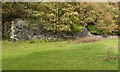
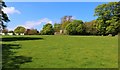
Walled garden at Largo Home Farm
One corner of the extensive wall surrounding the former kitchen garden at Home Farm, which would have supplied fruit and vegetables to Largo House in its heyday. The walls date to the late 16th or early 17th century, and were Category C listed https://britishlistedbuildings.co.uk/200341234-upper-largo-largo-home-farm-old-largo-house-walled-garden-leven-kennoway-and-largo-ward in 1984.
Image: © Richard Law
Taken: 3 Oct 2018
0.10 miles
2
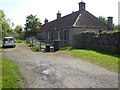
Cottages at Largo Place near Upper Largo
Image: © Michael Murray
Taken: 2 Jun 2007
0.10 miles
3
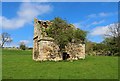
Old Doocot
This 17th century doocot (dovecote) lies close to Largo Home Farm.
See Upper Largo article https://www.geograph.org.uk/article/Upper-Largo
Image: © Bill Kasman
Taken: 29 Apr 2019
0.10 miles
4
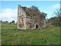
Derelict dovecot at Largo Home Farm
Dating from around the late 17th or early 18th century, as are many others in east Fife, the doocot at Largo Home Farm was Category B listed https://britishlistedbuildings.co.uk/200341235-upper-largo-largo-home-farm-dovecot-leven-kennoway-and-largo-ward#.W_GcktSLTGg in 1984. A large tree has taken root inside since the other photograph on this site Image was taken; ideally that needs removed before it does serious damage to the structure.
Image: © Richard Law
Taken: 30 Sep 2018
0.10 miles
5
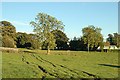
By Largo House
Field and cattle tracks by Largo House.
Image: © Jim Bain
Taken: 5 Sep 2007
0.11 miles
6
Largo House stables
Although the stables are heavily overgrown they are still relatively visible. The wall to the left is part of the walled gardens.
See Upper Largo article https://www.geograph.org.uk/article/Upper-Largo
Image: © Bill Kasman
Taken: 29 Apr 2019
0.11 miles
7
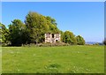
Largo House stables
Although the stables are heavily overgrown they are still relatively visible.
See Upper Largo article https://www.geograph.org.uk/article/Upper-Largo
Image: © Bill Kasman
Taken: 29 Apr 2019
0.11 miles
8
Largo House stables
Although the stables are heavily overgrown they are still relatively visible. Largo House Leisure Park is on the left.
See Upper Largo article https://www.geograph.org.uk/article/Upper-Largo
Image: © Bill Kasman
Taken: 29 Apr 2019
0.11 miles
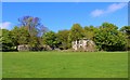
9

Ruins at Largo Home Farm
Farm buildings and an old doocot in a sad state of disrepair.
Image: © James Allan
Taken: 25 Jun 2007
0.11 miles
10
Largo House stables
Built in 1851 the stables are heavily overgrown but are still relatively visible.
See Upper Largo article https://www.geograph.org.uk/article/Upper-Largo
Image: © Bill Kasman
Taken: 29 Apr 2019
0.11 miles