IMAGES TAKEN NEAR TO
Kirkland Drive, LEVEN, KY8 3HX
Introduction
This page details the photographs taken nearby to Kirkland Drive, KY8 3HX by members of the Geograph project.
The Geograph project started in 2005 with the aim of publishing, organising and preserving representative images for every square kilometre of Great Britain, Ireland and the Isle of Man.

There are currently over 7.5m images from over14,400 individuals and you can help contribute to the project by visiting https://www.geograph.org.uk
Image Map
Images are licensed for reuse under creativecommons.org/licenses/by-sa/2.0
Notes
- Clicking on the map will re-center to the selected point.
- The higher the marker number, the further away the image location is from the centre of the postcode.
Image Listing (28 Images Found)
Images are licensed for reuse under creativecommons.org/licenses/by-sa/2.0
Image
Details
Distance
1
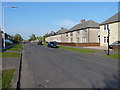
Houses on Den Walk
Den Walk is the main street through this estate, leading from Sea Road in the southwest to the A955 Methilhaven Road at its northeasterly end.
Image: © Richard Law
Taken: 11 May 2016
0.06 miles
2
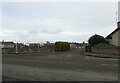
New housing development, Methil
On the former site of Kirkland High School, which was demolished in 2016, work begins on a new housing development. This is the main site entrance.
Image: © Bill Kasman
Taken: 27 Oct 2020
0.07 miles
3

Essential business
This vehicle repair garage was deemed an essential business and remained open throughout the 2020 coronavirus lockdown.
Image: © Bill Kasman
Taken: 30 May 2020
0.08 miles
4
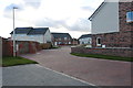
Keir Hardie Wynd, Methil
This new development is built on the site of former Fife Council premises.
Image: © Bill Kasman
Taken: 19 Mar 2020
0.09 miles
5
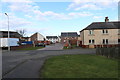
Keir Hardie Wynd, Methil
This new development is built on the site of former Fife Council premises. This is the entrance from Keir Hardie Street. There is another entrance from Methil Brae on the other side of the development.
Image: © Bill Kasman
Taken: 19 Mar 2020
0.09 miles
6
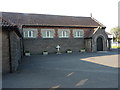
St Agatha's Catholic Church, Crossroads
Image: © Richard Law
Taken: 11 May 2016
0.10 miles
7

Kirkland High School, Methil
The large grass area on the other side of the wall was the site of Kirkland High School which was finally demolished towards the end of 2016. The demolition of the school was delayed due to the discovery of a nesting colony of bats (a protected species) in the school http://www.fifetoday.co.uk/news/drat-bats-we-can-t-demolish-kirkland-yet-1-4170448
Image: © Bill Kasman
Taken: 27 Aug 2017
0.10 miles
8
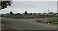
New housing development, Methil
On the former site of Kirkland High School, which was demolished in 2016, work begins on a new housing development.
Image: © Bill Kasman
Taken: 27 Oct 2020
0.10 miles
9
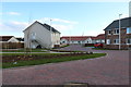
Keir Hardie Wynd, Methil
This new development is built on the site of former Fife Council premises.
Image: © Bill Kasman
Taken: 19 Mar 2020
0.11 miles
10
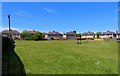
Ossian Park
Ossian Park is a large open grassy area and children's play park. It is in a secluded location and only locals are likely to know of it.
Image: © Bill Kasman
Taken: 30 May 2020
0.12 miles