IMAGES TAKEN NEAR TO
Clentry, KELTY, KY4 0JQ
Introduction
This page details the photographs taken nearby to KY4 0JQ by members of the Geograph project.
The Geograph project started in 2005 with the aim of publishing, organising and preserving representative images for every square kilometre of Great Britain, Ireland and the Isle of Man.

There are currently over 7.5m images from over14,400 individuals and you can help contribute to the project by visiting https://www.geograph.org.uk
Image Map
Images are licensed for reuse under creativecommons.org/licenses/by-sa/2.0
Notes
- Clicking on the map will re-center to the selected point.
- The higher the marker number, the further away the image location is from the centre of the postcode.
Image Listing (12 Images Found)
Images are licensed for reuse under creativecommons.org/licenses/by-sa/2.0
Image
Details
Distance
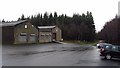
1
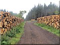
Glentry Sawmill
Looking NE with Bishop Hill in the distance.
Image: © Paul McIlroy
Taken: 21 Apr 2006
0.13 miles
2
Picnic table, Blairadam Forest
Looking across the Drumnagoil Burn.
Image: © Richard Webb
Taken: 25 Sep 2008
0.14 miles
3
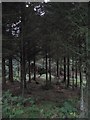
Blairadam Forest
Thinned spruce beside the road into Clenty.
Image: © Richard Webb
Taken: 25 Sep 2008
0.14 miles
4
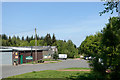
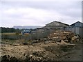
Forestry Commission depot at Blairadam Forest
There's no visitor centre or other facilities for the public at the depot but there is a car park, mainly hidden by the right hand trees. It's accessible from the B914 by a drive of around 1 km. along a well-surfaced tarmac road and gives access to waymarked paths.
Image: © Trevor Littlewood
Taken: 15 May 2019
0.16 miles
5
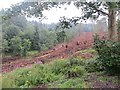
Felled area, Blairadam Forest
Taken shortly after a lot of the woodland by the two main car parks was felled. This is a slope above the Drumnagoil Burn, near the lower car park.
Image: © Richard Webb
Taken: 22 Jul 2013
0.17 miles
6
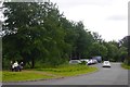
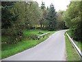
Forestry Commission car park, Blairadam Forest
The main car park, some distance into the forest.
Image: © Richard Webb
Taken: 7 Jul 2020
0.17 miles
7
Car park, Blairadam Forest
Car park beside the Forestry Commission offices and workshops.
Image: © Richard Webb
Taken: 26 Nov 2011
0.18 miles
8
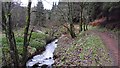
Drumnagoil Burn
Burn and well built path, Blairadam Forest.
--
2013
The trees on the right have been felled.
Image: © Richard Webb
Taken: 26 Nov 2011
0.19 miles
9
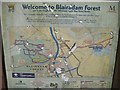
Cycle route information - Blairadam Forest
A handy place to break a motorway journey - bike routes near junction 4, M90.
Image: © Richard Webb
Taken: 25 Sep 2008
0.20 miles