IMAGES TAKEN NEAR TO
BURNTISLAND, KY3 9LQ
Introduction
This page details the photographs taken nearby to KY3 9LQ by members of the Geograph project.
The Geograph project started in 2005 with the aim of publishing, organising and preserving representative images for every square kilometre of Great Britain, Ireland and the Isle of Man.

There are currently over 7.5m images from over14,400 individuals and you can help contribute to the project by visiting https://www.geograph.org.uk
Image Map
Images are licensed for reuse under creativecommons.org/licenses/by-sa/2.0
Notes
- Clicking on the map will re-center to the selected point.
- The higher the marker number, the further away the image location is from the centre of the postcode.
Image Listing (20 Images Found)
Images are licensed for reuse under creativecommons.org/licenses/by-sa/2.0
Image
Details
Distance
1
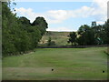
Burntisland Golf House Club, 3rd Hole, Whinnyhall
The short third hole at Burntisland, from tee to green.
Image: © Scott Cormie
Taken: 4 Aug 2022
0.07 miles
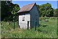
3
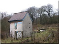
Binnend Borehole
A Fife & Kinross Water Board building on the B923.
Image: © M J Richardson
Taken: 30 Mar 2018
0.08 miles
4
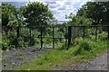
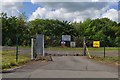
Access Gate
This track leads down to the Whinnyhill Landfill works.
Image: © Robert Struthers
Taken: 4 Jun 2017
0.11 miles
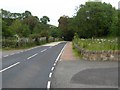
5
B923
There really is not much to photograph in this square
Image: © John Darcy
Taken: 6 Nov 2005
0.13 miles
6
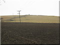
Fields north of Kinghorn
Newly ploughed arable in the foreground, with pasture beyond.
Image: © M J Richardson
Taken: 30 Mar 2018
0.14 miles
7
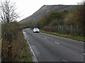
The B923 road, heading for Kinghorn Loch
In Fife.
Image: © James Denham
Taken: 2 Jul 2011
0.14 miles
8
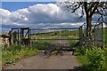
Gateway to Grangehill
This substantial roller gate almost looks like a security checkpoint rather than a farm entrance. The road leads up to the now derelict Grangehill Farm and is part of a network of footpaths in Fife. Pedestrian access is through the caged area on the right.
Image: © Robert Struthers
Taken: 4 Jun 2017
0.14 miles
9
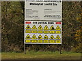
Dire fates, Whinnyhill landfill site
Aluminium waste has been stored on the site of the Burntisland oilshale mine and works. Now if only a certain chocolate factory had warnings like this.
Image: © Richard Webb
Taken: 23 Mar 2023
0.15 miles
10
Whinnyhall Landfill Site
Whinnyhall was used to dump 'red mud', a bauxite residue left over from the aluminium works at Burntisland. The works closed in 2002 and the site, which was a source of pollution into nearby Kinghorn Loch, has since been capped and stabilised and the leachate collected, processed and diverted.
Image: © Robert Struthers
Taken: 4 Jun 2017
0.15 miles