IMAGES TAKEN NEAR TO
Cluny, KIRKCALDY, KY2 6QS
Introduction
This page details the photographs taken nearby to KY2 6QS by members of the Geograph project.
The Geograph project started in 2005 with the aim of publishing, organising and preserving representative images for every square kilometre of Great Britain, Ireland and the Isle of Man.

There are currently over 7.5m images from over14,400 individuals and you can help contribute to the project by visiting https://www.geograph.org.uk
Image Map (Loading...)


Getting Data...Please wait
Leaflet Map data © OpenStreetMap
Images are licensed for reuse under creativecommons.org/licenses/by-sa/2.0
Notes
- Clicking on the map will re-center to the selected point.
- The higher the marker number, the further away the image location is from the centre of the postcode.
Image Listing (4 Images Found)
Images are licensed for reuse under creativecommons.org/licenses/by-sa/2.0
Image
Details
Distance
1
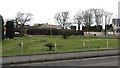
Cluny
The bottom of a garden, a triangle between the B922 and B981 at a road junction.
Image: © Richard Webb
Taken: 9 Mar 2012
0.02 miles
2
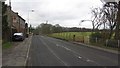
Cluny, Fife
The B981 in Cluny, view towards Cardenden.
Image: © Richard Webb
Taken: 9 Mar 2012
0.05 miles
3
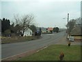
Clunie roundabout
Mini roundabout at Clunie road junction, viewed from the south
Image: © James Allan
Taken: 24 Mar 2006
0.08 miles
4
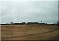
Muirton farm
Farm buildings and an adjacent mobile phone mast near Cluny Clays.
Image: © James Allan
Taken: 9 Mar 2015
0.25 miles