IMAGES TAKEN NEAR TO
Main Street, KIRKCALDY, KY2 5TH
Introduction
This page details the photographs taken nearby to Main Street, KY2 5TH by members of the Geograph project.
The Geograph project started in 2005 with the aim of publishing, organising and preserving representative images for every square kilometre of Great Britain, Ireland and the Isle of Man.

There are currently over 7.5m images from over14,400 individuals and you can help contribute to the project by visiting https://www.geograph.org.uk
Image Map
Images are licensed for reuse under creativecommons.org/licenses/by-sa/2.0
Notes
- Clicking on the map will re-center to the selected point.
- The higher the marker number, the further away the image location is from the centre of the postcode.
Image Listing (16 Images Found)
Images are licensed for reuse under creativecommons.org/licenses/by-sa/2.0
Image
Details
Distance
1
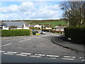
Auchtertool in Fife
Sitting astride the B925.
Image: © James Denham
Taken: 26 Apr 2010
0.03 miles
2
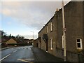
Former Auchtertool Warehouse
There is an Ordnance Survey benchmark on this building, visible on stone level with bottom of window between window and lamppost. See Image
Image: © Becky Williamson
Taken: 4 Jan 2021
0.05 miles
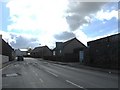
3
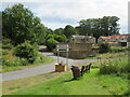
Auchtertool distillery
There was once a whisky distillery in the small Fife village of Auchtertool but it is long gone and the only traces remaining are the manager's house (centre frame) and the wall on the left of the image which bounded the distillery premises. The location of the distillery is now a private housing estate named, appropriately enough, 'The Maltings'.
Image: © Bill Kasman
Taken: 13 Apr 2019
0.06 miles
4
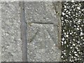
Benchmark, former Auchtertool Warehouse
Ordnance Survey benchmark, described on database at https://www.bench-marks.org.uk/bm140793. See also Image
Image: © Becky Williamson
Taken: 4 Jan 2021
0.07 miles
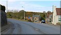
5
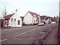
Auchtertool
West end of Auchtertool village on the A925 looking east
Image: © James Allan
Taken: 24 Mar 2006
0.08 miles
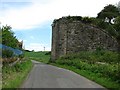
6
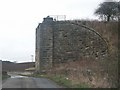
Victorian Support
Half a bridge. Less even. Only the east bridge abutment still stands complete to show the remnants of a bygone era when the iron road was king. Heading north out of Auchtertool toward Lochgelly.
Image: © Simon Johnston
Taken: 26 Mar 2006
0.12 miles
7
Auchtertool village welcome sign
Camilla, and Camilla Road.
Image: © M J Richardson
Taken: 13 Jul 2022
0.13 miles
8
Bridge buttress, Kirkcaldy District Railway
Only the eastern buttress is still full height, and it is some height. The railway was a freight only route serving collieries.
Image: © Richard Webb
Taken: 14 Jun 2011
0.15 miles
9
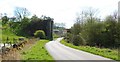
Former railway bridge
On the approach to Auchtertool from the Loch Gelly direction this buttress is part of a dismantled bridge from one of Fife's many long-lost railways.
Image: © Bill Kasman
Taken: 13 Apr 2019
0.15 miles