IMAGES TAKEN NEAR TO
Melville Place, KIRKCALDY, KY2 5SL
Introduction
This page details the photographs taken nearby to Melville Place, KY2 5SL by members of the Geograph project.
The Geograph project started in 2005 with the aim of publishing, organising and preserving representative images for every square kilometre of Great Britain, Ireland and the Isle of Man.

There are currently over 7.5m images from over14,400 individuals and you can help contribute to the project by visiting https://www.geograph.org.uk
Image Map
Images are licensed for reuse under creativecommons.org/licenses/by-sa/2.0
Notes
- Clicking on the map will re-center to the selected point.
- The higher the marker number, the further away the image location is from the centre of the postcode.
Image Listing (7 Images Found)
Images are licensed for reuse under creativecommons.org/licenses/by-sa/2.0
Image
Details
Distance
2
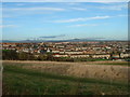
Kirkcaldy: Rabbit Braes
from Bennochy Road, looking over the big field at Rabbit Braes, to Templehall and the Lomond Hills in the background. Kirkcaldy like this part of Fife is a series of hill ridges, the underlying rock is old red sandstone. The fields here are remnant of the Bogie Mains Farm.
Image: © Kevin O'Kane
Taken: 21 Dec 2005
0.20 miles
3
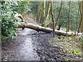
Obstructed footpath
A fallen tree across the footpath through Long Braes plantation.
Image: © James Allan
Taken: 12 Feb 2016
0.21 miles
5
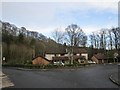
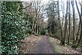
Dunvegan Avenue
A housing development in the wooded policies of Raith House.
Image: © Richard Webb
Taken: 27 Jan 2013
0.23 miles
6
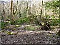
Windblown tree
In the Long Braes plantation, Kirkcaldy.
Image: © James Allan
Taken: 22 Feb 2016
0.24 miles
7
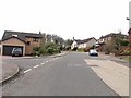
Dunvegan Ave by Raith
Modern housing on the former grounds of the old Raith House.
Image: © Jim Bain
Taken: 19 Mar 2006
0.24 miles