IMAGES TAKEN NEAR TO
Strathkinnes Road, KIRKCALDY, KY2 5PZ
Introduction
This page details the photographs taken nearby to Strathkinnes Road, KY2 5PZ by members of the Geograph project.
The Geograph project started in 2005 with the aim of publishing, organising and preserving representative images for every square kilometre of Great Britain, Ireland and the Isle of Man.

There are currently over 7.5m images from over14,400 individuals and you can help contribute to the project by visiting https://www.geograph.org.uk
Image Map
Images are licensed for reuse under creativecommons.org/licenses/by-sa/2.0
Notes
- Clicking on the map will re-center to the selected point.
- The higher the marker number, the further away the image location is from the centre of the postcode.
Image Listing (7 Images Found)
Images are licensed for reuse under creativecommons.org/licenses/by-sa/2.0
Image
Details
Distance
1
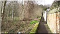
Raith Park wall
An old wall on the edge of Kirkcaldy with woodland on one side and housing on the other. Presumably an old policy wall.
Image: © Richard Webb
Taken: 9 Mar 2012
0.12 miles
2
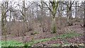
Woodland, Kirkcaldy
Probably once part of Raith Park.
Image: © Richard Webb
Taken: 9 Mar 2012
0.14 miles
3
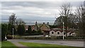
Bennochy Road
A fine view of the Forth from a residential area of Kirkcaldy.
Image: © Richard Webb
Taken: 9 Mar 2012
0.16 miles
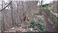
4
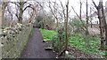
A steep path
A narrow and steep path runs between the gardens of Oriel Crescent and some woodland which was probably part of Raith Park.
Image: © Richard Webb
Taken: 9 Mar 2012
0.18 miles
5
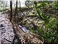
Woodland burn
Small burn flowing through Long Braes plantation on its way to Raith Lake.
Image: © James Allan
Taken: 22 Feb 2016
0.19 miles
6
Woodland, Kirkcaldy
A steep wooded slope beneath Sauchenbush Road.
Image: © Richard Webb
Taken: 9 Mar 2012
0.20 miles
7
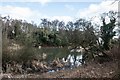
Pond north of Raith Lake, Kirkcaldy
Image: © Becky Williamson
Taken: 16 Feb 2020
0.24 miles