IMAGES TAKEN NEAR TO
Raith Grove, KIRKCALDY, KY2 5NQ
Introduction
This page details the photographs taken nearby to Raith Grove, KY2 5NQ by members of the Geograph project.
The Geograph project started in 2005 with the aim of publishing, organising and preserving representative images for every square kilometre of Great Britain, Ireland and the Isle of Man.

There are currently over 7.5m images from over14,400 individuals and you can help contribute to the project by visiting https://www.geograph.org.uk
Image Map
Images are licensed for reuse under creativecommons.org/licenses/by-sa/2.0
Notes
- Clicking on the map will re-center to the selected point.
- The higher the marker number, the further away the image location is from the centre of the postcode.
Image Listing (39 Images Found)
Images are licensed for reuse under creativecommons.org/licenses/by-sa/2.0
Image
Details
Distance
1
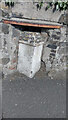
Old Milestone by the A910, Abbotshall Road, Kirkcaldy
A type milestone by the A910, Abbotshall Road, in parish of Abbotshall (Fife District), North of Beveridge Park roundabout, in recess in stone wall, West side of road.
Inscription reads:-
: Kirky. 1 / Dysart 2⅜ / Leven 9⅝ : : Auchl.3½ / C Gates 8⅛ / Dunferl. 12 :
Surveyed
Milestone Society National ID: FF_KCDF01
Image: © alan smeaton
Taken: 27 Apr 2024
0.03 miles
2
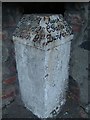
Old Milestone by the A910, Abbotshall Road, Kirkcaldy
A type milestone by the A910, Abbotshall Road, in parish of Abbotshall (Fife District), North of Beveridge Park roundabout, in recess in stone wall, West side of road.
Inscription reads:-
: Kirky. 1 / Dysart 2⅜ / Leven 9⅝ : : Auchl.3½ / C Gates 8⅛ / Dunferl. 12 :
Surveyed
Milestone Society National ID: FF_KCDF01
Image: © Milestone Society
Taken: Unknown
0.03 miles
3
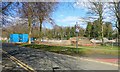
Construction site, Kirkcaldy
In Raith Drive, on the site of the former Raith Gates care home, new houses are being constructed.
Image: © Bill Kasman
Taken: 13 Apr 2019
0.03 miles
4
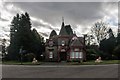
Beveridge Park Main Gate Lodge, Kirkcaldy
Image: © Becky Williamson
Taken: 16 Feb 2020
0.05 miles
5

Benchmark, Wall, Abbotshall Road, Kirkcaldy
Ordnance Survey benchmark, described on database at https://www.bench-marks.org.uk/bm37994.
Image: © Becky Williamson
Taken: 16 Feb 2020
0.05 miles
6
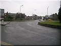
Balwearie Roundabout, Kirkcaldy
This is Balwearie Roundabout, near Kirkcaldy town centre.
There are four exits off this roundabout: Nicol Street (A910) (this will lead you down to the promenade) to the north; Abbotshall Road (leading to Balwearie Road, next right turnoff and Balwearie High School) to the north east; Bogily Road (B925) (leading to Southerton and Autchertool) to the south east and Abbotshall Road (leading to Forth avenue and Kirkcaldy Railway Station on the right at the next roundabout) to the south
Image: © Ian Thomson
Taken: 10 Mar 2008
0.06 miles
7
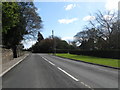
The B925 heading east near Beveridge Park
In Kirkcaldy in Fife.
Image: © James Denham
Taken: 26 Apr 2010
0.09 miles
8
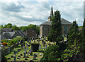
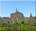
Abbotshall Church
This present United Presbyterian church was built in 1788 to serve the former parish of Abbotshall. It was built on the site of its predecessor which dated from in 1674. Today it is in normal use and serves the parish of Kirkcaldy and Dysart.
Image: © John Allan
Taken: 17 May 2010
0.09 miles
9
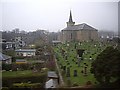
Abbotshall church and graveyard
See http://www.fife.50megs.com/Tour%20Abbotshall%20Churchyard%20Scotland/index.htm
Image: © Stanley Howe
Taken: 4 Apr 2009
0.10 miles
10
Abbotshall Churchyard
There has been a church and burial ground here for hundreds of years.
Image: © Paul McIlroy
Taken: 22 Jan 2007
0.10 miles