IMAGES TAKEN NEAR TO
Abbey Park Avenue, ST. ANDREWS, KY16 9HN
Introduction
This page details the photographs taken nearby to Abbey Park Avenue, KY16 9HN by members of the Geograph project.
The Geograph project started in 2005 with the aim of publishing, organising and preserving representative images for every square kilometre of Great Britain, Ireland and the Isle of Man.

There are currently over 7.5m images from over14,400 individuals and you can help contribute to the project by visiting https://www.geograph.org.uk
Image Map
Images are licensed for reuse under creativecommons.org/licenses/by-sa/2.0
Notes
- Clicking on the map will re-center to the selected point.
- The higher the marker number, the further away the image location is from the centre of the postcode.
Image Listing (102 Images Found)
Images are licensed for reuse under creativecommons.org/licenses/by-sa/2.0
Image
Details
Distance
1
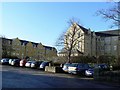
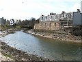
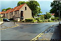
Kilrymont House
A recent residential development adjacent to St Andrews Memorial Hospital. The hospital is scheduled to close soon, and more housing is likely to take its place. If it is all to be painted yellow like these buildings, the 'Auld grey city by the sea' may have to change its by-name.
Image: © James Allan
Taken: 26 Jan 2009
0.05 miles
2
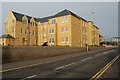
St Leonard's Fields, St Andrews
This striking new build lies just ofj Abbey Walk by Greyfriars School.
Image: © Jim Bain
Taken: 22 Apr 2006
0.06 miles
3
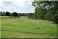
Woodburn Park, St Andrews
Well hidden area of parkland to the south of the Kinness Burn. Bounded by Glebe Road and Woodburn Terrace. Also known as Bankie Park.
Image: © Jim Bain
Taken: 19 May 2007
0.08 miles
4
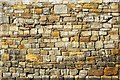
Abbey Wall, detail
Old towns used to reflect their surrounding geology. This wall has stood here for around 700 years.
Image: © Jim Bain
Taken: 24 Mar 2007
0.09 miles
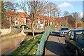
5
Shore Bridge, St Andrews
Looking back up the Kinness burn to Shore Bridge with Balfour Place on the far side and Woodburn Place on this side.
Image: © Jim Bain
Taken: 16 Apr 2006
0.10 miles
6
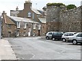
The Shore, St Andrews
The street is known as the Shore. This group of buildings are by the Shore Bridge end. The large wall to the right behind the cars was once the boundary wall of the Cathedral and much of it still stands.
Image: © Jim Bain
Taken: 16 Apr 2006
0.10 miles
7
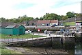
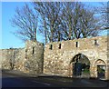
Harbour and Mill Port, St Andrews
The harbour gates between the inner and outer harbour to the right of shot. Behind is the Mill Port ( gate ) and the policy walls of the old Abbey. The area behind the wall is now occupied by St Leonards School.
Image: © Jim Bain
Taken: 21 May 2006
0.12 miles
8
Greenside Court
Red roofed Greenside Court from near the junction of Kinnessburn Road and Langlands Road. The normally clear Kinness Burn is heavily laden with silt after a night of heavy rain.
Image: © Jim Bain
Taken: 3 Mar 2007
0.13 miles
9
Abbey Wall
Remarkably well preserved walls dating from around the 12th or 13th century surround the ruinous cathedral of St Andrews.
Image: © James Allan
Taken: 26 Jan 2009
0.13 miles
10
Greenside Court, St Andrews
Greenside Place just above the Kinness Burn and the road into Greenside Court.
Image: © Jim Bain
Taken: 14 Jun 2008
0.13 miles