IMAGES TAKEN NEAR TO
ST. ANDREWS, KY16 8PA
Introduction
This page details the photographs taken nearby to KY16 8PA by members of the Geograph project.
The Geograph project started in 2005 with the aim of publishing, organising and preserving representative images for every square kilometre of Great Britain, Ireland and the Isle of Man.

There are currently over 7.5m images from over14,400 individuals and you can help contribute to the project by visiting https://www.geograph.org.uk
Image Map
Images are licensed for reuse under creativecommons.org/licenses/by-sa/2.0
Notes
- Clicking on the map will re-center to the selected point.
- The higher the marker number, the further away the image location is from the centre of the postcode.
Image Listing (12 Images Found)
Images are licensed for reuse under creativecommons.org/licenses/by-sa/2.0
Image
Details
Distance
1
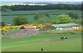
Denhead and Drumcarrow
Denhead and Drumcarrow just visible in the mist from the Denhead to Cameron farm road.
Image: © Jim Bain
Taken: 10 Feb 2008
0.04 miles
2
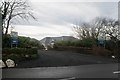
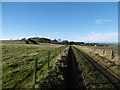
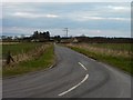
Downhill to Denhead
The Peat Inn to Strathkinness road heading downhill from near the high point of the shoulder over the east flank of Drumcarrow Craig.
Image: © Scott Cormie
Taken: 9 Apr 2019
0.06 miles
3
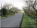
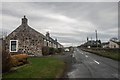
Denhead junction
The Peatinn to Strathkinnes road by the old Denhead farm buildings at the Denhead junction on a misty Sunday afternoon.
Image: © Jim Bain
Taken: 10 Feb 2008
0.08 miles
5
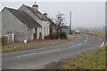
Denhead
Livery stables taken from the slopes of Drumcarrow.
Image: © Richard Webb
Taken: 29 May 2005
0.10 miles
6
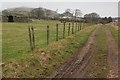
Denhead to Cameron path
The route uses a well surfaced road for much of its course, but there is a rather overgrown stretch to the south.
Image: © Richard Webb
Taken: 26 Nov 2015
0.13 miles
7
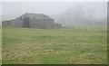
Denhead building
Old building by Denhead, function unknown to me.
Image: © Jim Bain
Taken: 10 Feb 2008
0.14 miles
8
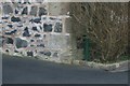
Benchmark at Elderbank, Denhead
Ordnance Survey benchmark, described on database at https://www.bench-marks.org.uk/bm115714. See also Image
Image: © Becky Williamson
Taken: 19 Jan 2020
0.14 miles
9
Down to Denhead
Minor road leading off the Peat Inn road into Denhead.
Image: © James Allan
Taken: 23 Mar 2011
0.15 miles
10
Elderbank, Denhead
There is an Ordnance Survey benchmark on the gable end of the property on the left. See Image
Image: © Becky Williamson
Taken: 19 Jan 2020
0.16 miles