IMAGES TAKEN NEAR TO
Watson Avenue, ST. ANDREWS, KY16 8JS
Introduction
This page details the photographs taken nearby to Watson Avenue, KY16 8JS by members of the Geograph project.
The Geograph project started in 2005 with the aim of publishing, organising and preserving representative images for every square kilometre of Great Britain, Ireland and the Isle of Man.

There are currently over 7.5m images from over14,400 individuals and you can help contribute to the project by visiting https://www.geograph.org.uk
Image Map
Images are licensed for reuse under creativecommons.org/licenses/by-sa/2.0
Notes
- Clicking on the map will re-center to the selected point.
- The higher the marker number, the further away the image location is from the centre of the postcode.
Image Listing (36 Images Found)
Images are licensed for reuse under creativecommons.org/licenses/by-sa/2.0
Image
Details
Distance
1
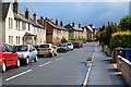
Boase Avenue, St Andrews
North end off, by its junction with Kinnessburn Road.
Image: © Jim Bain
Taken: 14 Jun 2008
0.06 miles
2

Happy Duck
A feature of the Kinness Burn in St Andrews is the ducks that line its banks in the city centre.
Image: © Jim Bain
Taken: 19 May 2007
0.11 miles
3
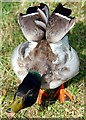
Angry Duck
A feature of the Kinness Burn in St Andrews is the ducks that line its banks in the city centre.
Image: © Jim Bain
Taken: 19 May 2007
0.12 miles
4
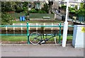
Bicycle or unicycle?
Chained to railings in Kinnessburn Road, St Andrews, I found this bicycle with a missing front wheel. It looked as though it had been there for some time. The missing front wheel was in the burn underneath the footbridge Image
Image: © Bill Kasman
Taken: 4 Aug 2018
0.12 miles
5
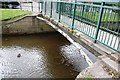
Found it!
In the Kinness Burn in St Andrews I found this bicycle wheel. It probably belongs to the bicycle in this image Image
Image: © Bill Kasman
Taken: 4 Aug 2018
0.12 miles
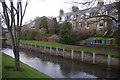
6
Kinness Burn
And Dempster Terrace, St Andrews.
Image: © Richard Webb
Taken: 8 Jan 2017
0.13 miles
7
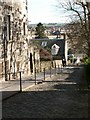
Ladebraes, St Andrews
From Queens Terrace looking north and down the steep brae to the Kinness burn and Kinnessburn Road
Image: © Jim Bain
Taken: 1 Apr 2006
0.13 miles
8
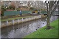
Kinness Burn
Looking over the burn towards Dempster Terrace.
Image: © Richard Webb
Taken: 8 Jan 2017
0.13 miles
9
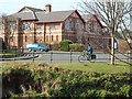
Boys Brigade
The rather imposing Boys Brigade hall at the foot of Greenside by the Kinness Burn.
Image: © Jim Bain
Taken: 7 Apr 2007
0.13 miles
10
Pipeland Road
The north end of Pipeland Road by the bowling club.
Image: © Jim Bain
Taken: 19 Jun 2012
0.13 miles