IMAGES TAKEN NEAR TO
Andrew Thom Place, Kinkell Terrace, ST. ANDREWS, KY16 8DY
Introduction
This page details the photographs taken nearby to Andrew Thom Place, Kinkell Terrace, KY16 8DY by members of the Geograph project.
The Geograph project started in 2005 with the aim of publishing, organising and preserving representative images for every square kilometre of Great Britain, Ireland and the Isle of Man.

There are currently over 7.5m images from over14,400 individuals and you can help contribute to the project by visiting https://www.geograph.org.uk
Image Map
Images are licensed for reuse under creativecommons.org/licenses/by-sa/2.0
Notes
- Clicking on the map will re-center to the selected point.
- The higher the marker number, the further away the image location is from the centre of the postcode.
Image Listing (40 Images Found)
Images are licensed for reuse under creativecommons.org/licenses/by-sa/2.0
Image
Details
Distance
2
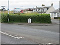
Old style signpost at St.Andrews
Stone sign set into a wall at the junction with the A917 and Grange Road, outlining settlements on both roads.
Image: © Scott Cormie
Taken: 12 Aug 2017
0.07 miles
3

Old Milestone by the A917, Grange, St Andrews parish
J type casting by the A917, in parish of St Andrews (Fife District), junction of the C41, Grange Road with the A917, set into North facing wall at junction.
Surveyed
Milestone Society National ID: FF_WMFF208
Image: © Milestone Society
Taken: Unknown
0.08 miles
4
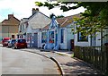
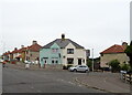
Shops, Woodburn Terrace
A small run of shops serving the Woodburn area of St Andrews.
Image: © Jim Bain
Taken: 19 May 2007
0.12 miles
5
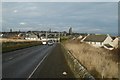
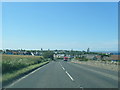
A917, looking into St Andrews
Road in from Crail and Kingsbarns.
Image: © Richard Webb
Taken: 8 Jan 2017
0.12 miles
7
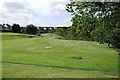
Woodburn Park, St Andrews
Well hidden area of parkland to the south of the Kinness Burn. Bounded by Glebe Road and Woodburn Terrace. Also known as Bankie Park.
Image: © Jim Bain
Taken: 19 May 2007
0.14 miles
8
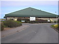
Entrance to the East Sands Leisure Centre
The view of the entrance to the East Sands Leisure Centre. The car park to the left of the building serves as a car park at the start of the Fife Coastal Path.
Image: © Sandy Gemmill
Taken: 14 Apr 2010
0.16 miles
9
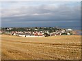
East end of St Andrews
New houses are at the very SE edge of town.
Image: © Jim Bain
Taken: 25 Sep 2005
0.16 miles
10

Braid Crescent, St Andrews
Southern edge of the town.
Image: © Richard Webb
Taken: 8 Jan 2017
0.17 miles