IMAGES TAKEN NEAR TO
Nelson Street, ST. ANDREWS, KY16 8AJ
Introduction
This page details the photographs taken nearby to Nelson Street, KY16 8AJ by members of the Geograph project.
The Geograph project started in 2005 with the aim of publishing, organising and preserving representative images for every square kilometre of Great Britain, Ireland and the Isle of Man.

There are currently over 7.5m images from over14,400 individuals and you can help contribute to the project by visiting https://www.geograph.org.uk
Image Map
Images are licensed for reuse under creativecommons.org/licenses/by-sa/2.0
Notes
- Clicking on the map will re-center to the selected point.
- The higher the marker number, the further away the image location is from the centre of the postcode.
Image Listing (83 Images Found)
Images are licensed for reuse under creativecommons.org/licenses/by-sa/2.0
Image
Details
Distance
1
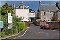
Wallace Street, St Andrews
View from the Bassaguard Industrial estate down the now blocked off Wallace Street to the west end of Kinnessburn Road at its junction with Largo Road.
Or the rear of the Kinnessburn chip shop which ever you prefer.
Image: © Jim Bain
Taken: 14 Jun 2008
0.08 miles
2
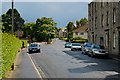
Pipleland Road, St Andrews
By its north end junction with Kinnessburn Road.
Image: © Jim Bain
Taken: 14 Jun 2008
0.08 miles
3
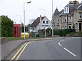
Street scene, St Andrews
A K6 type telephone box stands beside a grit bin on a wide verge near the junction.
In 1935, the Post Office commissioned a new kiosk from Sir Giles Gilbert Scott to celebrate the Jubilee of King George V. The K6 Jubilee Kiosk, as it is known, was similar to the K2 box, being made of cast iron and painted red but was 25% lighter in weight. By the end of the 1930s there were 20,000 K6 telephone boxes in use all over the UK.
Image: © Maigheach-gheal
Taken: 4 Apr 2010
0.09 miles
4
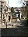
Ladebraes, St Andrews
From Queens Terrace looking north and down the steep brae to the Kinness burn and Kinnessburn Road
Image: © Jim Bain
Taken: 1 Apr 2006
0.09 miles
5
The Canongate
The Canongate from near the Botanical Gardens looking down to its junction with Largo Road. The area just in front of the car is where the old Anstruther and Thornton railway line crossed the Canongate.
Image: © Jim Bain
Taken: 5 May 2007
0.10 miles
6
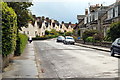
Wallace/Slone Streets, St Andrews
Looking along Wallace Street to Sloan Street with its cream coloured houses.
Image: © Jim Bain
Taken: 14 Jun 2008
0.10 miles
7
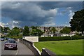
Pipeland Road
The north end of Pipeland Road by the bowling club.
Image: © Jim Bain
Taken: 19 Jun 2012
0.11 miles
8
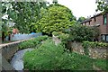
Kinness Burn, St Andrews
Looking north up the Kinness Burn from Kinnessburn Road by Dempster Crescent.
Image: © Jim Bain
Taken: 21 May 2006
0.11 miles
9
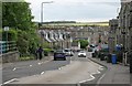
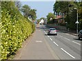
Bridge Street, St Andrews
Looking south along the A915.
Image: © Richard Sutcliffe
Taken: 21 May 2019
0.11 miles
10
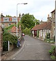
Fleming Place, St Andrews
Looking north down Fleming Place from its junction with Kinnessburn Road.
Image: © Jim Bain
Taken: 21 May 2006
0.11 miles