IMAGES TAKEN NEAR TO
Burnside, CUPAR, KY15 7SZ
Introduction
This page details the photographs taken nearby to Burnside, KY15 7SZ by members of the Geograph project.
The Geograph project started in 2005 with the aim of publishing, organising and preserving representative images for every square kilometre of Great Britain, Ireland and the Isle of Man.

There are currently over 7.5m images from over14,400 individuals and you can help contribute to the project by visiting https://www.geograph.org.uk
Image Map
Images are licensed for reuse under creativecommons.org/licenses/by-sa/2.0
Notes
- Clicking on the map will re-center to the selected point.
- The higher the marker number, the further away the image location is from the centre of the postcode.
Image Listing (23 Images Found)
Images are licensed for reuse under creativecommons.org/licenses/by-sa/2.0
Image
Details
Distance
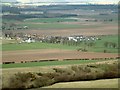
5
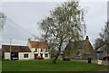
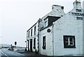
Pitlessie from the A914
I don't know for certain if this is the site of an old village green, as it isn't marked as such on maps. Nevertheless, it brings to mind what the village might have looked like in more bustling times before rural depopulation. Local boy David Wilkie immortalised a rare moment of rural history when he painted the following scene in 1804. http://www.nationalgalleries.org/collection/artists-a-z/W/6004/artist_name/Sir%20David%20Wilkie/record_id/2431 According to the RIAS architectural guide to The Kingdom of Fife, the distant gable in the painting has been identified as that of No.12 High Street.
Image: © kim traynor
Taken: 15 Jun 2013
0.11 miles
6
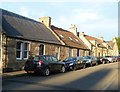
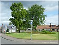
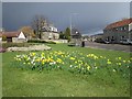
A road triangle, Pitlessie
A garden between three roads.
Image: © Richard Webb
Taken: 26 Apr 2013
0.12 miles
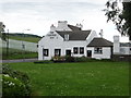
7
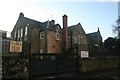
Pitlessie
The village seen from Cults Hill. The former maltings are easy to identify towards the right of the photograph, and the white village inn stands out to the left.
Image: © James Allan
Taken: 17 Apr 2006
0.12 miles
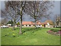
10
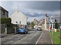
Pitlessie
The A914 side of a park triangle in Pitlessie.
Image: © Richard Webb
Taken: 26 Apr 2013
0.14 miles