IMAGES TAKEN NEAR TO
Beebykes, CUPAR, KY15 7BF
Introduction
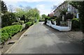
This page details the photographs taken nearby to Beebykes, KY15 7BF by members of the Geograph project.
The Geograph project started in 2005 with the aim of publishing, organising and preserving representative images for every square kilometre of Great Britain, Ireland and the Isle of Man.

There are currently over 7.5m images from over14,400 individuals and you can help contribute to the project by visiting https://www.geograph.org.uk
Image Map
Images are licensed for reuse under creativecommons.org/licenses/by-sa/2.0
Notes
- Clicking on the map will re-center to the selected point.
- The higher the marker number, the further away the image location is from the centre of the postcode.
Image Listing (365 Images Found)
Images are licensed for reuse under creativecommons.org/licenses/by-sa/2.0
Image
Details
Distance
1
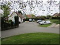
Beebykes, Falkland
See also this image Image]
See Falkland article http://www.geograph.org.uk/article/Falkland-An-historic-village
Image: © Bill Kasman
Taken: 29 Apr 2017
0.02 miles
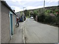
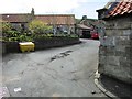
2
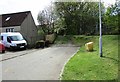
Beebykes, Falkland
First impressions suggest that this track leaving Beebykes goes somewhere interesting but it doesn't - it's simply an access track into a farmer's field!
See Falkland article http://www.geograph.org.uk/article/Falkland-An-historic-village
Image: © Bill Kasman
Taken: 23 Apr 2017
0.02 miles
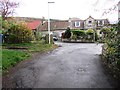
3
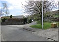
Beebykes, Falkland
The entrance to the small cul-de-sac of Beebykes from Well Brae.
See Falkland article http://www.geograph.org.uk/article/Falkland-An-historic-village
Image: © Bill Kasman
Taken: 23 Apr 2017
0.03 miles
4
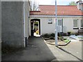
Castle Park, Falkland
From the middle of Castle Park Image] this passage ascends stairs and provides pedestrian access to/from Well Brae near Beebykes Image]
See Falkland article http://www.geograph.org.uk/article/Falkland-An-historic-village
Image: © Bill Kasman
Taken: 23 Apr 2017
0.04 miles
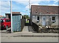
5
Well Brae, Falkland
Well Brae approaches the top of Victoria Place Image] The car in the far distance is parked at the beginning of the path to Liquorstane, Chapel Yard and Ladywell House Image] The right turn into Royal Terrace Image] also begins there.
See Falkland article http://www.geograph.org.uk/article/Falkland-An-historic-village
Image: © Bill Kasman
Taken: 23 Apr 2017
0.04 miles
6
Well Brae, Falkland
Looking towards Beebykes Image] The demolition site of the former St John's Works Image] can be seen on the right.
See Falkland article http://www.geograph.org.uk/article/Falkland-An-historic-village
Image: © Bill Kasman
Taken: 23 Apr 2017
0.05 miles
7
Victoria Place, Falkland
At the top of Victoria Place Image] it joins with Well Brae (to the right) and Royal Terrace (to the left).
See Falkland article http://www.geograph.org.uk/article/Falkland-An-historic-village
Image: © Bill Kasman
Taken: 16 Apr 2017
0.05 miles
8
Lane from Well Brae to Castle Park, Falkland
This is one of several short lanes connecting Well Brae with Castle Park Image]
See Falkland article http://www.geograph.org.uk/article/Falkland-An-historic-village
Image: © Bill Kasman
Taken: 23 Apr 2017
0.05 miles
9
Royal Terrace, Falkland
Looking round the first bend at the top of Royal Terrace Image]
See Falkland article http://www.geograph.org.uk/article/Falkland-An-historic-village
Image: © Bill Kasman
Taken: 23 Apr 2017
0.05 miles
10
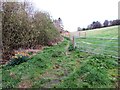
Path in Falkland
From the top of Victoria Place Image] this path runs for about one kilometre towards Chapel Yard and Ladywell House. See also this image Image]
See Falkland article http://www.geograph.org.uk/article/Falkland-An-historic-village
Image: © Bill Kasman
Taken: 16 Apr 2017
0.05 miles