IMAGES TAKEN NEAR TO
Dura View, CUPAR, KY15 5UN
Introduction
This page details the photographs taken nearby to Dura View, KY15 5UN by members of the Geograph project.
The Geograph project started in 2005 with the aim of publishing, organising and preserving representative images for every square kilometre of Great Britain, Ireland and the Isle of Man.

There are currently over 7.5m images from over14,400 individuals and you can help contribute to the project by visiting https://www.geograph.org.uk
Image Map
Images are licensed for reuse under creativecommons.org/licenses/by-sa/2.0
Notes
- Clicking on the map will re-center to the selected point.
- The higher the marker number, the further away the image location is from the centre of the postcode.
Image Listing (29 Images Found)
Images are licensed for reuse under creativecommons.org/licenses/by-sa/2.0
Image
Details
Distance
1
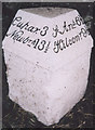
Old Milestone by the B940, Cupar Road, Piscottie, Kemback Parish
A stone with metal cap by the B940, in parish of Kemback (Fife District), Pitscottie, North end of village.
Surveyed
Milestone Society National ID: FF_CPPS03.
Image: © Milestone Society
Taken: Unknown
0.05 miles
2
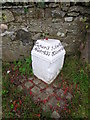
Milestone, Pitscottie
Milestone beside the B940. For a wider view of the stone Image
Milestones did not come into general use until the Turnpike Act of 1766 made them compulsory on turnpike roads, these roads were built by private enterprise under licence from the Government and maintained by tolls on those who used them. Before this Act milestones were put up occasionally, often as charitable acts and commemorations. Many Turnpike Act stones still exist. They are usually 2-3 ft high, with the initial letter or abbreviation of the nearest market town show on two faces, and the distance from it.
Image: © Maigheach-gheal
Taken: 13 Oct 2010
0.05 miles
3
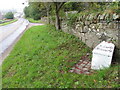
Milestone, Pitscottie
The milestone stands beside the B940.
Milestones are the original roadside heritage features with many dating back hundreds of years and these historic items are under threat from highway developments.
Image: © Maigheach-gheal
Taken: 13 Oct 2010
0.05 miles
4
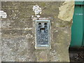
Ordnance Survey Flush Bracket S5084
The bracket can be found on the wall of Easter Pitscottie farmhouse. This benchmark has a recorded height of 64.813 metres above sea level.
For more detail see : https://www.bench-marks.org.uk/bm19378
Image: © Peter Wood
Taken: 10 May 2021
0.07 miles
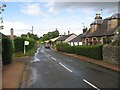
5
Easter Pitscottie Farm
Looking north-eastward from the B940
Image: © Peter Wood
Taken: 10 May 2021
0.07 miles
7
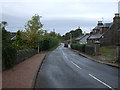
Minor road heading north out of Pitscottie
National Cycle Route 1.
Image: © JThomas
Taken: 22 Oct 2013
0.10 miles
8
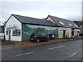
The White Chimneys, Pitscottie
Sandwich Bar and Tearoom.
Image: © JThomas
Taken: 22 Oct 2013
0.14 miles
9
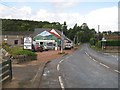
White Chimneys, Pitscottie
Sandwich bar on Cupar Road. I had just missed a rain shower, I was not to miss the next one!
Image: © Richard Webb
Taken: 12 Aug 2009
0.14 miles
10
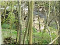
Ceres Burn in Dura Den
The stone wall is part of an abandoned watermill that has fallen into a ruinous state.
Image: © James Allan
Taken: 9 Apr 2007
0.14 miles