IMAGES TAKEN NEAR TO
Springfield, CUPAR, KY15 5QU
Introduction
This page details the photographs taken nearby to KY15 5QU by members of the Geograph project.
The Geograph project started in 2005 with the aim of publishing, organising and preserving representative images for every square kilometre of Great Britain, Ireland and the Isle of Man.

There are currently over 7.5m images from over14,400 individuals and you can help contribute to the project by visiting https://www.geograph.org.uk
Image Map
Images are licensed for reuse under creativecommons.org/licenses/by-sa/2.0
Notes
- Clicking on the map will re-center to the selected point.
- The higher the marker number, the further away the image location is from the centre of the postcode.
Image Listing (21 Images Found)
Images are licensed for reuse under creativecommons.org/licenses/by-sa/2.0
Image
Details
Distance
1

The River Eden at Springfield
Brown and in spate after 36 hours of rain. The Russell Mill concrete block manufactory is just downstream.
Image: © M J Richardson
Taken: 7 Aug 2008
0.01 miles
2
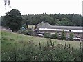
Russell Mill at Springfield
A factory making concrete blocks and similar products - its own fabric seems a little in need of TLC.
Image: © M J Richardson
Taken: 7 Aug 2008
0.05 miles
3
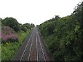
Railway between Ladybank and Cupar
Looking southwest towards Springfield Station.
Image: © M J Richardson
Taken: 7 Aug 2008
0.08 miles
4
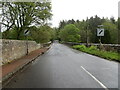
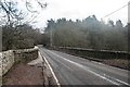
Road crossing a bridge over the River Eden as it leaves Springfield
Looking south-eastward.
Image: © Peter Wood
Taken: 12 May 2021
0.11 miles
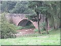
5
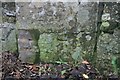
Benchmark on Clushgreen Bridge, Springfield
Spanning the River Eden east of Springfield, this bridge has an Ordnance Survey benchmark on it. This is described on the benchmark database at https://www.bench-marks.org.uk/bm114171. See also Image
Image: © Becky Williamson
Taken: 17 Dec 2019
0.11 miles
6
Clushgreen Bridge, Springfield
This bridge spans the River Eden east of the village of Springfield. It has an Ordnance Survey benchmark on it. See Image
Image: © Becky Williamson
Taken: 17 Dec 2019
0.11 miles
7
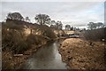
River Eden at Clushgreen Bridge, Springfield
Looking east.
Image: © Becky Williamson
Taken: 17 Dec 2019
0.11 miles
8
Bridge over the River Eden at Springfield
The river muddy and in spate after 36 hours of rain.
Image: © M J Richardson
Taken: 7 Aug 2008
0.12 miles
9
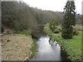
River Eden near Springfield
The River Eden heading upstream from the bridge east of Springfield.
Image: © Scott Cormie
Taken: 13 Apr 2019
0.15 miles
10
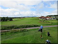
Elmwood golf course
A view looking back down the 18th green and fairway, with the clubhouse at right. The Lomond Hills are in the background. Photo taken from viewing steps next to the first tee.
Image: © Scott Cormie
Taken: 25 Jul 2016
0.17 miles