IMAGES TAKEN NEAR TO
Lebanon Terrace, CUPAR, KY15 4JP
Introduction
This page details the photographs taken nearby to Lebanon Terrace, KY15 4JP by members of the Geograph project.
The Geograph project started in 2005 with the aim of publishing, organising and preserving representative images for every square kilometre of Great Britain, Ireland and the Isle of Man.

There are currently over 7.5m images from over14,400 individuals and you can help contribute to the project by visiting https://www.geograph.org.uk
Image Map
Images are licensed for reuse under creativecommons.org/licenses/by-sa/2.0
Notes
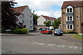
- Clicking on the map will re-center to the selected point.
- The higher the marker number, the further away the image location is from the centre of the postcode.
Image Listing (85 Images Found)
Images are licensed for reuse under creativecommons.org/licenses/by-sa/2.0
Image
Details
Distance
1
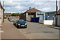
Front Lebanon, Cupar
The east end of Front Lebanon. The industrial buildings on the right recently vacated by Heggies body shop, stand on the site of the old town's gas works.
Image: © Jim Bain
Taken: 15 Jun 2008
0.05 miles
2
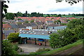
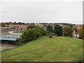
Lebanon, Cupar
The last remains of a sawmill, Dye works and the town's gas works from Moat Hill.
At the turn of the 1900s this area was one of two major industrial sites in Cupar. Both have now largely been replaced with retail and housing.
At the turn of the 1900s this area was one of two major industrial sites in Cupar. Both have now largely been replaced with retail and housing and this last remnant in Lebanon seems to heading the same way with the relocation of Heggies to other premises in the town.
Image: © Jim Bain
Taken: 12 Jun 2008
0.05 miles
3
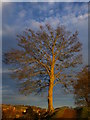
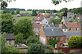
Moathill tree
Looking towards Upper Dalgain, Cupar from Moathill.
Image: © Jackie Proven
Taken: 30 Nov 2013
0.07 miles
4
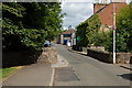
Front Lebanon, Cupar
Bridge over the Lady Burn about mid way along the street.
Image: © Jim Bain
Taken: 15 Jun 2008
0.09 miles
5
Moot Hill
Moot or Moat Hill in Cupar, a natural feature but suspected as being a fortified site.
Image: © Richard Webb
Taken: 21 Sep 2013
0.09 miles
6
From Moat Hill, Cupar
Looking out across Lebanon towards the hospital on the edge of town from Moat Hill.
The more modern housing in mid picture is on the site of the former Lebanon Linen works.
Image: © Jim Bain
Taken: 12 Jun 2008
0.10 miles
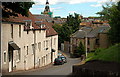
7
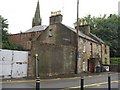
Burnside North, Cupar
The old Burn Square Tannery buildings at the foot of Burnside North.
Image: © Jim Bain
Taken: 14 Jun 2008
0.11 miles
8
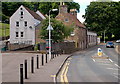
North Burnside, Cupar
The foot of the one-way street down from Moat Hill, with the spire of St John's Church behind.
Image: © M J Richardson
Taken: 7 Aug 2008
0.11 miles
9
Houston Court, Cupar
Just off South Lebanon.
Image: © Jim Bain
Taken: 15 Jun 2008
0.11 miles
10
Moat Hill Road, Cupar
Street scene dominated by the refurbished old tannery buildings.
Corn Exchange tower in scaffolding.
Apart from the scaffolding, cars and tar, not much has changed, I suspect, in this view over the past 100 years.
Image: © Jim Bain
Taken: 15 Jun 2008
0.12 miles