IMAGES TAKEN NEAR TO
Castlehill Place, CUPAR, KY15 4HP
Introduction
This page details the photographs taken nearby to Castlehill Place, KY15 4HP by members of the Geograph project.
The Geograph project started in 2005 with the aim of publishing, organising and preserving representative images for every square kilometre of Great Britain, Ireland and the Isle of Man.

There are currently over 7.5m images from over14,400 individuals and you can help contribute to the project by visiting https://www.geograph.org.uk
Image Map
Images are licensed for reuse under creativecommons.org/licenses/by-sa/2.0
Notes
- Clicking on the map will re-center to the selected point.
- The higher the marker number, the further away the image location is from the centre of the postcode.
Image Listing (161 Images Found)
Images are licensed for reuse under creativecommons.org/licenses/by-sa/2.0
Image
Details
Distance
1
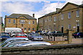
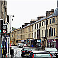
Castle Hill Buildings, Cupar
The old school buildings now used by the council for admin. and other uses.
Image: © Jim Bain
Taken: 14 Jun 2008
0.01 miles
2
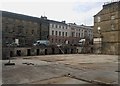
Cleared Demolition Site
This demolition site is now clear and an interesting
series of cellars (which go under the main road)
are revealed.
Image: © Texas Radio and The Big Beat
Taken: 12 Sep 2013
0.03 miles
3
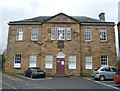
Old school building on Castlehill
The armorial tablet above the doorway was removed from the town's demolished tolbooth.
Image: © kim traynor
Taken: 22 Oct 2011
0.03 miles
4
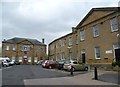
Buildings on Castlehill
These buildings, which appear to be Fife Council Offices, date from 1806 and 1908. A plaque nearby explains that they were a school until 1975. I assume that to mean they housed the burgh school. In 1552, the hill was the scene for the staging of an expanded version of David Lindsay's play 'The Satyre Of The Thrie Estaitis', which was first performed in Linlithgow Palace earlier in the same year.
Image: © kim traynor
Taken: 22 Oct 2011
0.03 miles
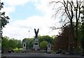
7
War Memorial Cupar
War Memorial viewed from St Catherine Street.
Image: © edward mcmaihin
Taken: 2 Sep 2012
0.04 miles
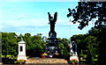
8
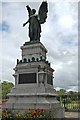
War memorial, Cupar
Rather imposing war memorial showing the winged angel of victory. Unveiled 29 April 1922 by Field Marshal Earl Haig and Provost Stark. It stands at the bottom of St Catherine Street with her back to the park.
Image: © Jim Bain
Taken: 9 Jul 2006
0.04 miles
9
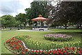
Hood Park, Cupar
Bandstand and flower bends looking towards the Eden.
Image: © Jim Bain
Taken: 9 Jul 2006
0.04 miles
10
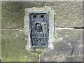
Ordnance Survey Flush Bracket S4593
The bracket can be found on the roadside wall of Council Buildings in Cupar.
This benchmark has a recorded height of 21.52 metres above sea level.
For more detail see : https://www.bench-marks.org.uk/bm11551
Image: © Peter Wood
Taken: 11 May 2021
0.04 miles