IMAGES TAKEN NEAR TO
Castlebank Road, CUPAR, KY15 4HL
Introduction
This page details the photographs taken nearby to Castlebank Road, KY15 4HL by members of the Geograph project.
The Geograph project started in 2005 with the aim of publishing, organising and preserving representative images for every square kilometre of Great Britain, Ireland and the Isle of Man.

There are currently over 7.5m images from over14,400 individuals and you can help contribute to the project by visiting https://www.geograph.org.uk
Image Map
Images are licensed for reuse under creativecommons.org/licenses/by-sa/2.0
Notes
- Clicking on the map will re-center to the selected point.
- The higher the marker number, the further away the image location is from the centre of the postcode.
Image Listing (81 Images Found)
Images are licensed for reuse under creativecommons.org/licenses/by-sa/2.0
Image
Details
Distance
1
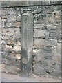
Former tollbar
Surveyed by the Milestone Society. This 150cm high stone post in Cupar is opposite the Cupar East former tollhouse. It would have supported one end of the actual toll bar.
Image: © Chris Minto
Taken: 5 Aug 2008
0.03 miles
2
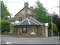
Former Tollhouse by the A91, East Road, Cupar
Toll House by the A91, in parish of Cupar (Fife District), No. 1, East Road.
HES Scotland Category B listed.
Reference: LB24303 http://portal.historicenvironment.scot/designation/LB24303
Surveyed
Milestone Society National ID: FF.CUP01
Image: © Milestone Society
Taken: Unknown
0.04 miles
3
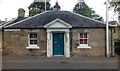
East Toll House, Cupar
This toll house was constructed in 1825 and continued in use as such until 1878, when road tolls were finally abolished.
Image: © Euan Nelson
Taken: 7 Aug 2014
0.05 miles
4
The East Toll House, Cupar
From a bygone age when you paid to use each section of the road network. This toll house stands on what then would have been the Eastern edge of Cupar. At this point the eastern road out of the town splits, with the left road going to St Andrews and the right road going to Pitscottie. Tolls were collected here from around 1791, but the house was not built until around 1825. The toll keepers collected tolls here until an act of Parliament abolished toll roads nationwide in 1878.
Image: © Jim Bain
Taken: 24 Jan 2007
0.05 miles
6
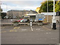
Electric car charging point, Cupar
Electric car charging point in the car park at East Burnside in Cupar.
Image: © Scott Cormie
Taken: 29 Sep 2018
0.11 miles
7
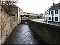
Lady Burn, Cupar
Lady Burn by Burnside Cupar, looking down stream.
Image: © Jim Bain
Taken: 24 Jan 2007
0.12 miles
8
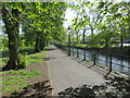
Walkway beside the River Eden in Nicholson Park, Cupar
Looking north-eastward.
Image: © Peter Wood
Taken: 11 May 2021
0.12 miles
9
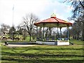
Bandstand, Haugh Park, Cupar
Dating from c.1900, the bandstand is cast-iron, octagonal in shape and a Category B listed building. https://www.britishlistedbuildings.co.uk/200360179-bandstand-hood-park-cupar#.Wr4xmzGWytU
Image: © G Laird
Taken: 29 Mar 2018
0.13 miles
10
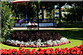
Braehead Gardens Cupar
Beautiful gardens with the bandstand in the background.
Image: © edward mcmaihin
Taken: 2 Sep 2012
0.13 miles