IMAGES TAKEN NEAR TO
Balgarvie Crescent, CUPAR, KY15 4EQ
Introduction
This page details the photographs taken nearby to Balgarvie Crescent, KY15 4EQ by members of the Geograph project.
The Geograph project started in 2005 with the aim of publishing, organising and preserving representative images for every square kilometre of Great Britain, Ireland and the Isle of Man.

There are currently over 7.5m images from over14,400 individuals and you can help contribute to the project by visiting https://www.geograph.org.uk
Image Map
Images are licensed for reuse under creativecommons.org/licenses/by-sa/2.0
Notes
- Clicking on the map will re-center to the selected point.
- The higher the marker number, the further away the image location is from the centre of the postcode.
Image Listing (42 Images Found)
Images are licensed for reuse under creativecommons.org/licenses/by-sa/2.0
Image
Details
Distance
1
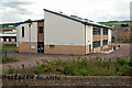
St. Columba's RC Primary, Cupar
Smart new building on North Union St, opened in Nov 2006
Image: © Jim Bain
Taken: 12 Jun 2008
0.06 miles
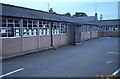
2
Prefabricated Wooden Modular school building
Built on the playing fields to cope the growing school population in the sixties these temporary buildings remained in use for forty years.
Image: © Alisdair Mclean
Taken: 17 Aug 2002
0.11 miles
3
Prefabricated Concrete school building
The old Bell Baxter High School in Westport Place featured "the huts" this particular building was the site of two Art Department rooms.To the left was Mr Harry Johnston's pottery class
Image: © Alisdair Mclean
Taken: 17 Aug 2002
0.11 miles
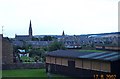
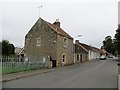
4
Moat Hill Road, Cupar
The trees are on Moot or Moat Hill, an esker.
Image: © Richard Webb
Taken: 21 Sep 2013
0.11 miles
5
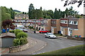
Haymount Park, Cupar
Modern estate tucked in behind the main road. From the tail of Moat Hill.
Image: © Jim Bain
Taken: 12 Jun 2008
0.12 miles
6
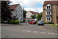
Houston Court, Cupar
Just off South Lebanon.
Image: © Jim Bain
Taken: 15 Jun 2008
0.14 miles
7
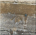
OS Cut Mark: Cupar, former church
https://www.bench-marks.org.uk/bm69496
Image: © thejackrustles
Taken: 4 Sep 2021
0.16 miles
8
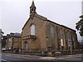
A former church building, Cupar
At the junction of North Union Street and West Port (A91). Built in C19 as St Michael's Church, Westport; subsequently used as a gymnasium by a local academy; now disused. See http://canmore.org.uk/site/99088/cupar-west-port-st-michaels-church
Image: © Stanley Howe
Taken: 6 Oct 2015
0.17 miles
9
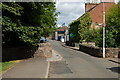
Front Lebanon, Cupar
Bridge over the Lady Burn about mid way along the street.
Image: © Jim Bain
Taken: 15 Jun 2008
0.17 miles
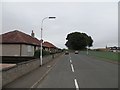
10
Moat Hill Road, Cupar
Westward view to buildings which predate the 20th century housing here.
Image: © Richard Webb
Taken: 21 Sep 2013
0.17 miles