IMAGES TAKEN NEAR TO
Kilmaron Crescent, CUPAR, KY15 4DS
Introduction
This page details the photographs taken nearby to Kilmaron Crescent, KY15 4DS by members of the Geograph project.
The Geograph project started in 2005 with the aim of publishing, organising and preserving representative images for every square kilometre of Great Britain, Ireland and the Isle of Man.

There are currently over 7.5m images from over14,400 individuals and you can help contribute to the project by visiting https://www.geograph.org.uk
Image Map
Images are licensed for reuse under creativecommons.org/licenses/by-sa/2.0
Notes
- Clicking on the map will re-center to the selected point.
- The higher the marker number, the further away the image location is from the centre of the postcode.
Image Listing (6 Images Found)
Images are licensed for reuse under creativecommons.org/licenses/by-sa/2.0
Image
Details
Distance
1
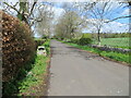
Driveway giving access to Kinloss House and Farm
Looking north-westward.
Image: © Peter Wood
Taken: 11 May 2021
0.14 miles
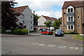
2
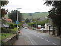
Bank Street, Cupar
Heading downhill into Cupar from the north.
Image: © Scott Cormie
Taken: 29 Sep 2018
0.14 miles
3
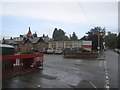
Adamson Health Care Campus
Community hospital on Bank Street, Cupar.
Note the blue sky, it was raining hard and for the next hour the blue sky was visible, just out of reach while I got wetter and wetter.
Image: © Richard Webb
Taken: 4 Oct 2013
0.15 miles
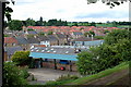
4
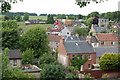
From Moat Hill, Cupar
Looking out across Lebanon towards the hospital on the edge of town from Moat Hill.
The more modern housing in mid picture is on the site of the former Lebanon Linen works.
Image: © Jim Bain
Taken: 12 Jun 2008
0.18 miles
5
Houston Court, Cupar
Just off South Lebanon.
Image: © Jim Bain
Taken: 15 Jun 2008
0.21 miles
6
Lebanon, Cupar
The last remains of a sawmill, Dye works and the town's gas works from Moat Hill.
At the turn of the 1900s this area was one of two major industrial sites in Cupar. Both have now largely been replaced with retail and housing.
At the turn of the 1900s this area was one of two major industrial sites in Cupar. Both have now largely been replaced with retail and housing and this last remnant in Lebanon seems to heading the same way with the relocation of Heggies to other premises in the town.
Image: © Jim Bain
Taken: 12 Jun 2008
0.24 miles