IMAGES TAKEN NEAR TO
High Road, CUPAR, KY14 7BE
Introduction
This page details the photographs taken nearby to High Road, KY14 7BE by members of the Geograph project.
The Geograph project started in 2005 with the aim of publishing, organising and preserving representative images for every square kilometre of Great Britain, Ireland and the Isle of Man.

There are currently over 7.5m images from over14,400 individuals and you can help contribute to the project by visiting https://www.geograph.org.uk
Image Map
Images are licensed for reuse under creativecommons.org/licenses/by-sa/2.0
Notes
- Clicking on the map will re-center to the selected point.
- The higher the marker number, the further away the image location is from the centre of the postcode.
Image Listing (41 Images Found)
Images are licensed for reuse under creativecommons.org/licenses/by-sa/2.0
Image
Details
Distance
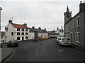
2
Low Road, Auchtermuchty
At the junction with Crosshills.
Image: © Mark Anderson
Taken: 15 Aug 2021
0.11 miles
3
Outskirts of Auchtermuchty
Photographer is above the pavement of the main road.
Image: © C Michael Hogan
Taken: 10 Jun 2011
0.14 miles
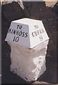
5
A91 Low Road Milestone
Milestone with cast-iron cap on the A91 Low Road in Auchtermuchty.
Image: © Scott Cormie
Taken: 7 Oct 2022
0.17 miles
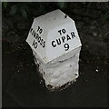
6
Old Milestone by the A91, Low Road, Auchtermuchty
'C' type by the A91, in parish of Auchtermuchty (Fife District), Auchtermuchty, Low Road, by wall, 300m West of B936 junction, opposite The Bungalow.
Inscription reads:-
: TO / KINROSS / 10 : : TO / CUPAR / 9 :
Surveyed
Milestone Society National ID: FF_CPKR09
Image: © Milestone Society
Taken: Unknown
0.17 miles
7
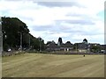
Field, Auchtermuchty
View from the new Co-op car park.
Image: © Richard Webb
Taken: 21 Aug 2022
0.18 miles
9
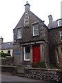
Guides Hall
High Street, Auchtermuchty. See http://canmoremapping.rcahms.gov.uk/index.php?action=do_details&cache_name=aWRudW1saW5rLDIyMzEwN19zZWFyY2h0eXBlLGFkdmFuY2VkX29yYQ==&set=0&list_z=0&numlink=223107
Image: © Stanley Howe
Taken: 17 May 2014
0.18 miles
10
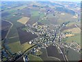
Auchtermuchty from the air
Looking north-west across the town.
Image: © James Allan
Taken: 20 Feb 2010
0.18 miles