IMAGES TAKEN NEAR TO
Robertson Crescent, CUPAR, KY14 6AW
Introduction
This page details the photographs taken nearby to Robertson Crescent, KY14 6AW by members of the Geograph project.
The Geograph project started in 2005 with the aim of publishing, organising and preserving representative images for every square kilometre of Great Britain, Ireland and the Isle of Man.

There are currently over 7.5m images from over14,400 individuals and you can help contribute to the project by visiting https://www.geograph.org.uk
Image Map
Images are licensed for reuse under creativecommons.org/licenses/by-sa/2.0
Notes
- Clicking on the map will re-center to the selected point.
- The higher the marker number, the further away the image location is from the centre of the postcode.
Image Listing (46 Images Found)
Images are licensed for reuse under creativecommons.org/licenses/by-sa/2.0
Image
Details
Distance
1
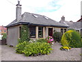
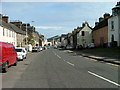
Gowanlea, Cupar Road, Newburgh
An urban cottage by the A913.
Image: © Stanley Howe
Taken: 12 Aug 2015
0.07 miles
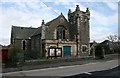
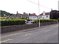
2
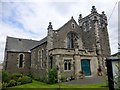
Newburgh Parish Church
Newburgh Parish Church was built between 1905 and 1906, facing south onto the road towards the east of Newburgh High Street, opposite the school and within walking distance of the town cemetery.
Image: © Rude Health
Taken: 30 Jul 2015
0.08 miles
3
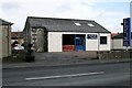
Newburgh Flooring
Business on Cupar Road, Newburgh. The building was originally a United Secession Church built in 1885. It was later converted to a community hall, known as the Livingstone Hall. Since then it has been a commercial garage and petrol filling station, before being changed to its present form.
Image: © Richard Sutcliffe
Taken: 2 Mar 2020
0.08 miles
4
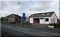
Newburgh Flooring
Business on Cupar Road, Newburgh. The building was originally a United Secession Church built in 1885. It was later converted to a community hall, known as the Livingstone Hall. Since then it has been a commercial garage and petrol filling station, before being changed to its present form.
Image: © Richard Sutcliffe
Taken: 2 Mar 2020
0.08 miles
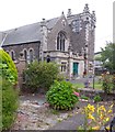
6
Newburgh Parish Church
A Category C listed church, dating from 1906.
Image: © Richard Sutcliffe
Taken: 2 Mar 2020
0.09 miles
7
Newburgh Parish Church
Church of Scotland, on Cupar Road (A913).
Image: © Stanley Howe
Taken: 12 Aug 2015
0.09 miles
8
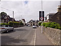
Entering Newburgh High Street from Cupar Road
Start of 30mph speed restriction through town on A913.
Image: © Stanley Howe
Taken: 12 Aug 2015
0.10 miles
9
Car Park and school buildings by Cupar Road (A913) in Newburgh
The A913 also serves as NCP777 (sign on lamp-post); and the banner behind, on the school, announces its support for cycling.
Image: © Stanley Howe
Taken: 12 Aug 2015
0.11 miles
10
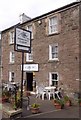
The Abbey Inn, Cupar Road
Newburgh, at the junction of Tay Street with the A913.
Image: © Stanley Howe
Taken: 12 Aug 2015
0.12 miles