IMAGES TAKEN NEAR TO
The Stackyard, KINROSS, KY13 9GF
Introduction
This page details the photographs taken nearby to The Stackyard, KY13 9GF by members of the Geograph project.
The Geograph project started in 2005 with the aim of publishing, organising and preserving representative images for every square kilometre of Great Britain, Ireland and the Isle of Man.

There are currently over 7.5m images from over14,400 individuals and you can help contribute to the project by visiting https://www.geograph.org.uk
Image Map
Images are licensed for reuse under creativecommons.org/licenses/by-sa/2.0
Notes
- Clicking on the map will re-center to the selected point.
- The higher the marker number, the further away the image location is from the centre of the postcode.
Image Listing (29 Images Found)
Images are licensed for reuse under creativecommons.org/licenses/by-sa/2.0
Image
Details
Distance
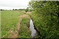
1
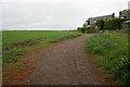
Track beside the Stackyard
The track leads to Burleigh Sands and Loch Leven.
Image: © Richard Sutcliffe
Taken: 18 May 2019
0.02 miles
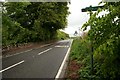
3
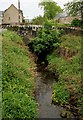
Bridge over the Burleigh Burn
The A911 crosses the burn.
Image: © Richard Sutcliffe
Taken: 18 May 2019
0.04 miles
4
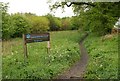
Community woodland beside Burleigh Castle
Image: © Richard Sutcliffe
Taken: 18 May 2019
0.04 miles
7
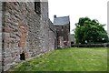
Burleigh Castle
The origins of Burleigh Castle date back to 1446, when the lands hereabout were granted to Sir John Balfour of Balgarvie by James II. Some time soon afterwards the Balfour family built a tower house here, and this forms the basis of the north tower that can be seen today.
Image: © Mary Rodgers
Taken: 8 Jun 2018
0.06 miles
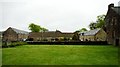
8
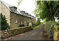
Burleigh Castle farm steading
Part of the Category B listed [http://portal.historicenvironment.scot/designation/LB19054] farmhouse and outbuildings, built in the early 19th century. The road leads round the back to the farmhouse (Burleigh House).
Image: © Richard Sutcliffe
Taken: 18 May 2019
0.07 miles
9
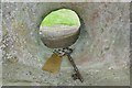
Key to the Castle
The origins of Burleigh Castle date back to 1446, when the lands hereabout were granted to Sir John Balfour of Balgarvie by James II. Some time soon afterwards the Balfour family built a tower house here, and this forms the basis of the north tower you can see today. To gain access to the castle you have to go to a little cottage where you are given the key.
Image: © Mary Rodgers
Taken: 8 Jun 2018
0.07 miles
10
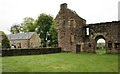
Burleigh Castle
The ornamental tower, adjacent to the A911 road, and part of the farm steading on the other side. The castle is a Scheduled Monument [http://portal.historicenvironment.scot/designation/SM90045].
Image: © Richard Sutcliffe
Taken: 18 May 2019
0.07 miles