IMAGES TAKEN NEAR TO
St. Marys Place, KIRKCALDY, KY1 2RG
Introduction
This page details the photographs taken nearby to St. Marys Place, KY1 2RG by members of the Geograph project.
The Geograph project started in 2005 with the aim of publishing, organising and preserving representative images for every square kilometre of Great Britain, Ireland and the Isle of Man.

There are currently over 7.5m images from over14,400 individuals and you can help contribute to the project by visiting https://www.geograph.org.uk
Image Map
Images are licensed for reuse under creativecommons.org/licenses/by-sa/2.0
Notes
- Clicking on the map will re-center to the selected point.
- The higher the marker number, the further away the image location is from the centre of the postcode.
Image Listing (52 Images Found)
Images are licensed for reuse under creativecommons.org/licenses/by-sa/2.0
Image
Details
Distance
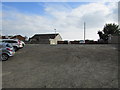
1
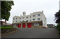
Fire station on Dunnikier Road, Kirkcaldy
A Category B listed building.
Image: © JThomas
Taken: 21 Jul 2021
0.05 miles
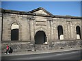
3
Nairn's building
The facade of one of Kirkcaldy's many disused linoleum factories, once a staple industry of the town but now almost non-existent.
Image: © James Allan
Taken: 23 Jul 2007
0.09 miles
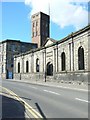
4
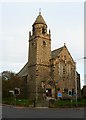
Former Dunnikier Free Church from Victoria Road
Now Our Lady of Perpetual Succour St. Maries R.C. Church.
Image: © kim traynor
Taken: 16 Oct 2011
0.10 miles
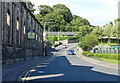
5
Top of Fish Wynd, Kirkcaldy
This rough car park off St Mary's Road, Kirkcaldy, leads to the top of Fish Wynd, a steep set of steps leading down to the harbour. The lamp-post next to the house indicates the top of the steps. For a closer view of the Wynd see this photo Image]
Image: © Bill Kasman
Taken: 3 Oct 2015
0.11 miles
6
Former M. Nairn and Co. building along the High Street
Image: © Mat Fascione
Taken: 22 Jul 2019
0.12 miles
7
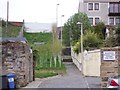
Fish Wynd, Kirkcaldy
A set of steep sets leading to/from the harbour. For a view of the top of the Wynd see this photo Image]
Image: © Ian Calderwood
Taken: 30 Apr 2012
0.12 miles
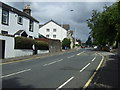
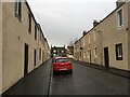
8

High Street, Kirkcaldy
The East end (it's really the north end) of the Lang Toon's long high street. Passing Nairn's Linoleum works, now the Priory Campus of The Adam Smith College.
Image: © Richard Webb
Taken: 20 Sep 2009
0.12 miles
10
M. Nairn and Co.
Former linoleum works. Some of the buildings are used by The Adam Smith College
Image: © Richard Webb
Taken: 20 Sep 2009
0.13 miles