IMAGES TAKEN NEAR TO
Whytemans Brae, KIRKCALDY, KY1 2LE
Introduction
This page details the photographs taken nearby to Whytemans Brae, KY1 2LE by members of the Geograph project.
The Geograph project started in 2005 with the aim of publishing, organising and preserving representative images for every square kilometre of Great Britain, Ireland and the Isle of Man.

There are currently over 7.5m images from over14,400 individuals and you can help contribute to the project by visiting https://www.geograph.org.uk
Image Map
Images are licensed for reuse under creativecommons.org/licenses/by-sa/2.0
Notes
- Clicking on the map will re-center to the selected point.
- The higher the marker number, the further away the image location is from the centre of the postcode.
Image Listing (13 Images Found)
Images are licensed for reuse under creativecommons.org/licenses/by-sa/2.0
Image
Details
Distance
1
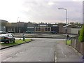
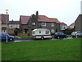
Kirkcaldy, Smeaton, Cedar Avenue
Smeaton is a housing scheme in North Kirkcaldy.
Smeaton is a deprived neighbour and is quite high in the Scottish Executive Multiple Index of Deprivation.
The streets are all named after trees, sadly no Cedars are growing on this street. Since the photo was taken work has been done to the roundabout.
NT2893 also contains part of Dunnikier Park, Pannie Den Wood parts of Overton too.
Image: © Kevin O'Kane
Taken: 26 Oct 2004
0.10 miles
2
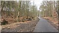
Middle Den
A newly resurfaced path runs through a wild looking urban woodland. There is a mountain bike trail in here as well.
Image: © Richard Webb
Taken: 9 Mar 2012
0.15 miles
3
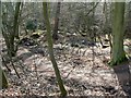
Wild corner in the suburbs
A small piece of unkempt woodland alongside the B981.
Image: © James Allan
Taken: 17 Feb 2009
0.15 miles
4
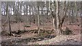
Middle Den
A fine piece of woodland inside Kirkcaldy.
Image: © Richard Webb
Taken: 9 Mar 2012
0.18 miles
6

Skate park, Dunniker Park
Concrete ramps in a big open area on the edge of Kirkcaldy.
Image: © Richard Webb
Taken: 9 Mar 2012
0.21 miles
8

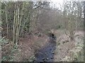
The Den Burn
A ford used by a mountain bike track.
Image: © Richard Webb
Taken: 9 Mar 2012
0.21 miles
9
Entrance to Middle Den, Kirkcaldy
My regular lunch-time walk.
Image: © Becky Williamson
Taken: 17 Feb 2020
0.21 miles
10

Wood off Dunniker Way
A small beech wood near Kirkcaldy High School.
Image: © Richard Webb
Taken: 9 Mar 2012
0.22 miles