IMAGES TAKEN NEAR TO
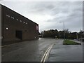
Junction Road, KIRKCALDY, KY1 2BH
Introduction
This page details the photographs taken nearby to Junction Road, KY1 2BH by members of the Geograph project.
The Geograph project started in 2005 with the aim of publishing, organising and preserving representative images for every square kilometre of Great Britain, Ireland and the Isle of Man.

There are currently over 7.5m images from over14,400 individuals and you can help contribute to the project by visiting https://www.geograph.org.uk
Image Map
Images are licensed for reuse under creativecommons.org/licenses/by-sa/2.0
Notes
- Clicking on the map will re-center to the selected point.
- The higher the marker number, the further away the image location is from the centre of the postcode.
Image Listing (14 Images Found)
Images are licensed for reuse under creativecommons.org/licenses/by-sa/2.0
Image
Details
Distance
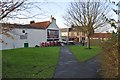
1
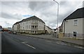
New housing development, Kirkcaldy
In Overton Road this new housing development, still under construction, will consist of 161 homes for rent http://cinmagazine.co.uk/building-work-begins-on-161-new-affordable-homes-for-kirkcaldy/
Image: © Bill Kasman
Taken: 30 Jul 2017
0.04 miles
2
New housing development, Kirkcaldy
These new houses are being built in Maltings Road, Kirkcaldy. They are part of the same development as those in this image Image
Image: © Bill Kasman
Taken: 30 Jul 2017
0.10 miles
3
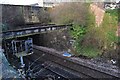
Vanished Railway Station
The Fife Circle railway line passes under St Clair Street here. Sinclairtown Station was on this site between 1847 and c.1968 - the steel beams supported the booking hall and stairs descended to platform level. The closed-up doors and windows can be seen in the remaining stone wall - see Image for a view from St Clair Street.
Image: © Robert Struthers
Taken: 30 Dec 2014
0.11 miles
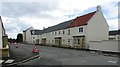
4
New housing development, Kirkcaldy
These houses, still under construction, are in Smeaton Road. They are part of the same development as those in this image Image
Image: © Bill Kasman
Taken: 30 Jul 2017
0.13 miles
6
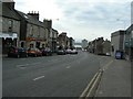
St Clair Street
Looking towards the Forth.
Image: © James Allan
Taken: 17 Feb 2009
0.14 miles
7
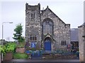
Pathhead Baptist Church
The steeple used to be higher which is why it now looks somewhat truncated.
Image: © Ian Calderwood
Taken: 8 Jun 2010
0.15 miles
8
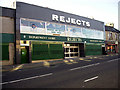
Rejects Department Store, St Clair Street
Image: © gordon povey
Taken: 24 Aug 2007
0.17 miles
9
Open ground, Sinclairtown
Old maps show a continuous line of buildings along St Clair Street at this location; at some time they were demolished, leaving this patch of open ground.
Image: © Robert Struthers
Taken: 30 Dec 2014
0.18 miles
10
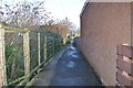
Sinclairtown Footpath
This short footpath runs between some waste ground and a car park.
Image: © Robert Struthers
Taken: 30 Dec 2014
0.21 miles