IMAGES TAKEN NEAR TO
Knockhill View, DUNFERMLINE, KY12 9NG
Introduction
This page details the photographs taken nearby to Knockhill View, KY12 9NG by members of the Geograph project.
The Geograph project started in 2005 with the aim of publishing, organising and preserving representative images for every square kilometre of Great Britain, Ireland and the Isle of Man.

There are currently over 7.5m images from over14,400 individuals and you can help contribute to the project by visiting https://www.geograph.org.uk
Image Map
Images are licensed for reuse under creativecommons.org/licenses/by-sa/2.0
Notes
- Clicking on the map will re-center to the selected point.
- The higher the marker number, the further away the image location is from the centre of the postcode.
Image Listing (12 Images Found)
Images are licensed for reuse under creativecommons.org/licenses/by-sa/2.0
Image
Details
Distance
1
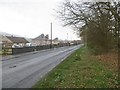
Steelend
A former mining village, under Saline Hill.
Image: © Richard Webb
Taken: 24 Apr 2015
0.05 miles
2
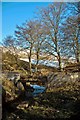
Small aqueduct in Saline Glen, Fife
Saline Glen
Image: © Brian Innes
Taken: 4 Mar 2010
0.07 miles
3
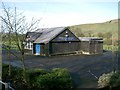
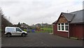
Steelend Miners Social Club
There are only ex- miners in Steelend.
Image: © Paul McIlroy
Taken: 17 Feb 2006
0.08 miles
4
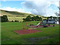
Children's play park
Swings and chute in Steelend park, with Saline hill in the background.
Image: © James Allan
Taken: 23 Aug 2012
0.11 miles
5
Steelend Miners Welfare Club
Social club in a small village under Saline Hill. Steelend was the centre for a network of private collieries around Saline and Knock Hill that were worked until 1975.
Image: © Richard Webb
Taken: 30 Jan 2012
0.15 miles
6
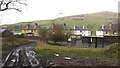
Steelend
A former mining village serving a variety of privately owned pits, the last closing in 1974.
Image: © Richard Webb
Taken: 30 Jan 2012
0.20 miles
7
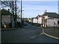
Steelend
This former mining village is situated on the B914 which runs from Saline to Kelty.
Image: © Paul McIlroy
Taken: 17 Feb 2006
0.20 miles
8

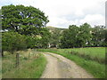
Saline Burn, Steelend
Wooded stream at the side of a large and well cared for public open space.
Image: © Richard Webb
Taken: 25 Sep 2008
0.21 miles
10
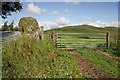
Bandrum Standing Stone
This large stone by a field gate is approximately 1.5m x 1.5m x 2m high. Another stone about 90m to the west forms part of the boundary wall of Saline Golf Course.
Image: © Walter Baxter
Taken: 5 Aug 2011
0.23 miles