IMAGES TAKEN NEAR TO
Sandhaven, DUNFERMLINE, KY12 8JG
Introduction
This page details the photographs taken nearby to Sandhaven, KY12 8JG by members of the Geograph project.
The Geograph project started in 2005 with the aim of publishing, organising and preserving representative images for every square kilometre of Great Britain, Ireland and the Isle of Man.

There are currently over 7.5m images from over14,400 individuals and you can help contribute to the project by visiting https://www.geograph.org.uk
Image Map
Images are licensed for reuse under creativecommons.org/licenses/by-sa/2.0
Notes
- Clicking on the map will re-center to the selected point.
- The higher the marker number, the further away the image location is from the centre of the postcode.
Image Listing (329 Images Found)
Images are licensed for reuse under creativecommons.org/licenses/by-sa/2.0
Image
Details
Distance
1
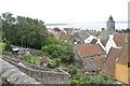
Culross Fife
View from Culross Palace gardens across rooftops of Culross
Image: © Eddie Mackinnon
Taken: 2 Jul 2005
0.00 miles
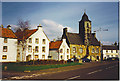
2
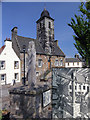
Culross Tron and Town House
This is a replica of the Tron which was a vertical wooden pillar with a hinged cross beam carrying scale pans on each end. One pan for weights and one for measures. Local produce such as coal and salt were weighed here by the Tron Master. The inset is taken from the plaque that can be seen on the base plinth. Culross Town Hall, with spire, can be seen behind the Tron.
Image: © Nigel J C Turnbull
Taken: 7 Jun 2008
0.00 miles
3
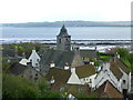
Culross and the Firth of Forth
In 1575, George Bruce bought the lease of a disused colliery from Culross Abbey and began developing coalmining and salt panning on this part of the Firth of Forth. King James VI granted royal burgh status in 1588, allowing Bruce to participate in foreign trade which proved lucrative. After the 17th century the burgh suffered a slow decline, its population dwindling from several thousand people at the height of its prosperity to a mere 578 in 1951. Many of its crumbling buildings were facing inevitable demolition when, in 1932, the National Trust for Scotland stepped in and began an extensive restoration of the burgh, which has created today's impressive 17thC time capsule.
Image: © kim traynor
Taken: 14 May 2012
0.00 miles
4

Town House and village houses at Culross
Looking across from one of the upper terraces of the garden of the Palace, and beyond to Bo'ness on the other side of the Firth of Forth.
Image: © M J Richardson
Taken: 26 Feb 2013
0.00 miles
5
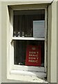
Notice in a window, Culross
The top notice reads:
WANTED
GOOD WOMEN
Must be able to cook,
clean, sew, dig worms and
clean fish.
Must have boat and motor.
PLEASE SEND
PICTURE OF
BOAT & MOTOR
Image: © Richard Sutcliffe
Taken: 1 Jun 2021
0.01 miles
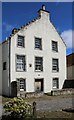
6
Culross, Town House
A mediaeval village (pronounced COO-russ, with the stress on the first syllable and an indistinct vowel in the second - a monument of 1642 Image uses the spelling "The Cooras") with many houses renovated by the National Trust for Scotland. Red pantiles are common along the Fife coast.
Image: © Colin Smith
Taken: Unknown
0.01 miles
7
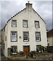
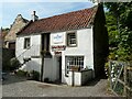
Robertson House, Sandhaven, Culross
Modernised 17th Century house and B-listed: http://data.historic-scotland.gov.uk/pls/htmldb/f?p=2200:15:0::::BUILDING:23986 .
Image: © Bill Harrison
Taken: 9 Apr 2009
0.01 miles
8
Robertson's House
A Category B listed https://portal.historicenvironment.scot/designation/LB23986 17th century house in Culross. Note the sundial in the wall.
Image: © Richard Sutcliffe
Taken: 24 Apr 2024
0.01 miles
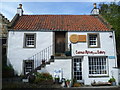
10
The Biscuit Cafe
The Culross Pottery Gallery is on the ground floor. The cafe on the first floor extends out at the rear of the property to a small outdoor seating area. The building is 18th century and is Category B listed http://portal.historicenvironment.scot/designation/LB23991.
Image: © Richard Sutcliffe
Taken: 1 Jun 2021
0.01 miles