IMAGES TAKEN NEAR TO
Garvock Hill, DUNFERMLINE, KY12 7RW
Introduction
This page details the photographs taken nearby to Garvock Hill, KY12 7RW by members of the Geograph project.
The Geograph project started in 2005 with the aim of publishing, organising and preserving representative images for every square kilometre of Great Britain, Ireland and the Isle of Man.

There are currently over 7.5m images from over14,400 individuals and you can help contribute to the project by visiting https://www.geograph.org.uk
Image Map
Images are licensed for reuse under creativecommons.org/licenses/by-sa/2.0
Notes
- Clicking on the map will re-center to the selected point.
- The higher the marker number, the further away the image location is from the centre of the postcode.
Image Listing (11 Images Found)
Images are licensed for reuse under creativecommons.org/licenses/by-sa/2.0
Image
Details
Distance
1
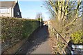
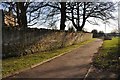
Dunfermline Footpath
This footpath runs from Garvock Hill to Dalcross Way. It follows the line of a former railway loop which connected the Fife Circle line with the Dunfermline to Stirling Line.
Image: © Robert Struthers
Taken: 6 Feb 2015
0.08 miles
2
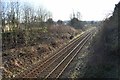
Fife Circle Railway Line
Looking south along the Fife Circle line from Garvock Hill.
Image: © Robert Struthers
Taken: 6 Feb 2015
0.09 miles
3
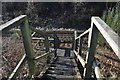
Railway Access Stairway
These steps on the Fife Circle railway line are used by Scottish Woodlands as access for keeping track-side vegetation under control.
Image: © Robert Struthers
Taken: 6 Feb 2015
0.10 miles
4
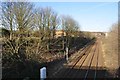
Fife Circle Railway Line
Looking north along the Fife Circle line from Garvock Hill. There used to be a railway junction (Touch South Junction) here many years ago where a loop of track connected to the long-gone Dunfermline and Stirling Line. The line would have curved away to the left. No trace of the junction remains.
Image: © Robert Struthers
Taken: 6 Feb 2015
0.11 miles
5
Dunfermline Footpath
A short path which runs between Garvock Hill and Garvock Bank.
Image: © Robert Struthers
Taken: 6 Feb 2015
0.11 miles
6
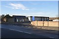
The Vine Church
The Vine Church is situated in the former premises of a lemonade manufacturer.
Image: © Robert Struthers
Taken: 6 Feb 2015
0.12 miles
7
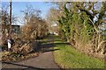
Dunfermline Footpath
This footpath runs from Garvock Hill to Halbeath Road. It follows the boundary of the 19th century Touch bleachfield.
Image: © Robert Struthers
Taken: 6 Feb 2015
0.15 miles
9
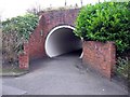
Pedestrian Tunnel
This tunnel allows pedestrians to cross under the Fife Circle railway line. The roadway under the adjacent bridge is too narrow for a conventional pavement.
Image: © Robert Struthers
Taken: 23 Mar 2012
0.23 miles
10
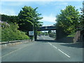
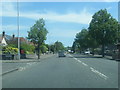
A907 Halbeath Road passing under railway
Image: © Colin Pyle
Taken: 11 Jun 2015
0.23 miles