IMAGES TAKEN NEAR TO
Alexandra Street, KIRKCALDY, KY1 1HH
Introduction
This page details the photographs taken nearby to Alexandra Street, KY1 1HH by members of the Geograph project.
The Geograph project started in 2005 with the aim of publishing, organising and preserving representative images for every square kilometre of Great Britain, Ireland and the Isle of Man.

There are currently over 7.5m images from over14,400 individuals and you can help contribute to the project by visiting https://www.geograph.org.uk
Image Map
Images are licensed for reuse under creativecommons.org/licenses/by-sa/2.0
Notes
- Clicking on the map will re-center to the selected point.
- The higher the marker number, the further away the image location is from the centre of the postcode.
Image Listing (28 Images Found)
Images are licensed for reuse under creativecommons.org/licenses/by-sa/2.0
Image
Details
Distance
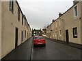
3
Victoria Hotel
Hotel on Victoria Road formerly the home of celebrated furniture manufacturer AH McIntosh
Image: © Graham Hogg
Taken: 12 Oct 2019
0.09 miles
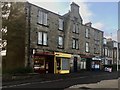
4
New housing development, Kirkcaldy
Still under construction this new housing development in Victoria Road is being built on the site of a former Vauxhall Motors dealership.
Image: © Bill Kasman
Taken: 30 Jul 2017
0.10 miles
6
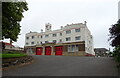
Fire station on Dunnikier Road, Kirkcaldy
A Category B listed building.
Image: © JThomas
Taken: 21 Jul 2021
0.16 miles
7
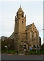
Former Dunnikier Free Church from Victoria Road
Now Our Lady of Perpetual Succour St. Maries R.C. Church.
Image: © kim traynor
Taken: 16 Oct 2011
0.17 miles
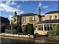
8
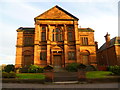
St. Andrew's Parish Church, Victoria Road
For its history, see http://www.bennochyparishchurch.org.uk/history/standrews/history.html
Image: © kim traynor
Taken: 16 Oct 2011
0.18 miles
9
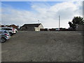
Top of Fish Wynd, Kirkcaldy
This rough car park off St Mary's Road, Kirkcaldy, leads to the top of Fish Wynd, a steep set of steps leading down to the harbour. The lamp-post next to the house indicates the top of the steps. For a closer view of the Wynd see this photo Image]
Image: © Bill Kasman
Taken: 3 Oct 2015
0.19 miles
10
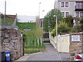
Fish Wynd, Kirkcaldy
A set of steep sets leading to/from the harbour. For a view of the top of the Wynd see this photo Image]
Image: © Ian Calderwood
Taken: 30 Apr 2012
0.19 miles