IMAGES TAKEN NEAR TO
Rosebery Grove, DUNFERMLINE, KY11 9YL
Introduction
This page details the photographs taken nearby to Rosebery Grove, KY11 9YL by members of the Geograph project.
The Geograph project started in 2005 with the aim of publishing, organising and preserving representative images for every square kilometre of Great Britain, Ireland and the Isle of Man.

There are currently over 7.5m images from over14,400 individuals and you can help contribute to the project by visiting https://www.geograph.org.uk
Image Map
Images are licensed for reuse under creativecommons.org/licenses/by-sa/2.0
Notes
- Clicking on the map will re-center to the selected point.
- The higher the marker number, the further away the image location is from the centre of the postcode.
Image Listing (41 Images Found)
Images are licensed for reuse under creativecommons.org/licenses/by-sa/2.0
Image
Details
Distance
1
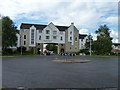
Harbour Place
Residential accommodation arching across pavement and roadway.
Image: © James Allan
Taken: 11 Jul 2011
0.08 miles
3
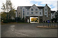
Entrance to St Davids Harbour
Looking south through the arch provided by housing, from Harbour Drive, with the Forth Bridge 3.4 km away through the arch.
Image: © M J Richardson
Taken: 4 May 2012
0.08 miles
4
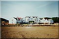
Dalgety Bay Harbour Construction
The re-development of Dalgety Bay harbour in 1993. (Exact day & month unknown).
Image: © Stuart Taylor
Taken: 16 Jun 1993
0.09 miles
5
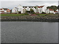
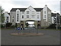
St David's Harbour, Dalgety Bay
Looking across the harbour to Harbour Place, and the way out to the rest of the world through an archway of houses straight ahead
Image: © M J Richardson
Taken: 4 May 2012
0.09 miles
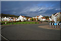
6

Footpath to Forth Reach
The footpath from the main road, Harbour Drive, to Forth Reach.
Image: © Sandy Gemmill
Taken: 21 Sep 2021
0.11 miles
7
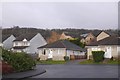
Spinnaker Way, Dalgety Bay
1990s houses.
Image: © Richard Webb
Taken: 15 Dec 2019
0.12 miles
9

The Moorings, St David:s Harbour
Centre piece of a central green area by St David's Harbour ringed by apartment blocks.
Image: © Oliver Dixon
Taken: 22 Mar 2022
0.14 miles
10

Old boundary wall at St Davids
The southwest extent of the policies of Donibristle House or Dunybirsal as it was spelt in the mid 18th century.
Image: © Alan Reid
Taken: 12 Nov 2022
0.14 miles