IMAGES TAKEN NEAR TO
Donibristle Industrial Park, Hillend, DUNFERMLINE, KY11 9HZ
Introduction
This page details the photographs taken nearby to KY11 9HZ by members of the Geograph project.
The Geograph project started in 2005 with the aim of publishing, organising and preserving representative images for every square kilometre of Great Britain, Ireland and the Isle of Man.

There are currently over 7.5m images from over14,400 individuals and you can help contribute to the project by visiting https://www.geograph.org.uk
Image Map
Images are licensed for reuse under creativecommons.org/licenses/by-sa/2.0
Notes
- Clicking on the map will re-center to the selected point.
- The higher the marker number, the further away the image location is from the centre of the postcode.
Image Listing (13 Images Found)
Images are licensed for reuse under creativecommons.org/licenses/by-sa/2.0
Image
Details
Distance
1
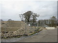
Demolition on Beech Way
Site clearance at the Donibristle Industrial Estate.
Image: © M J Richardson
Taken: 15 Mar 2017
0.01 miles
2
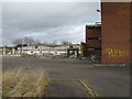
Demolition at Donibristle
A derelict building on the Donibristle Industrial Estate in the process of demolition.
Image: © M J Richardson
Taken: 15 Mar 2017
0.03 miles
3
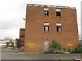
Derelict Building at Donibristle
A derelict building on the Donibristle Industrial Estate in the process of demolition.
Image: © M J Richardson
Taken: 15 Mar 2017
0.03 miles
4
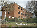
Derelict building at Donibristle
A building on the Donibristle Industrial Estate in the process of demolition.
Image: © M J Richardson
Taken: 15 Mar 2017
0.05 miles
5
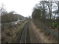
Railway at Donibristle
Part of the Fife Circle. Looking west towards Dalgety Bay Station. The road running alongside is the A921.
Image: © M J Richardson
Taken: 15 Mar 2017
0.07 miles
6

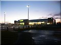
Asda got out of bed early?
To take this photo? Yes.
A dawn photo of one of the local purveyors of weekly necessities. The property holding arm of Asda bought this industrial area in Dalgety Bay for just under £9m earlier this year from Stockland Halladale who in turn snapped up the 11.7 acre site for under £2m from BAE Systems in 2005. Asda occupy about half the area on the site of the former John Sutcliffe building. That's a nice return in my book. Seems a hefty price for industrial land though. Good for Asda/Halladale that the Council didn't listen to the local objections and allowed it through on appeal. However it's here now and it is being used. Tesco seems just as busy as ever. Is it just me or has the addition of competition not resulted in any savings in your purse either? If anything it's had the opposite. Bah!
Waitrose or Sainsbury would have worked very well in this area methinks.
http://www.geograph.org.uk/photo/1045504
Image: © Simon Johnston
Taken: 9 Nov 2008
0.08 miles
7
Asda - Dalgety Bay
Up to 'the Asdas' to do the shopping when it's quiet? Nope, just a driveby.
Just what to do when you get woken up early and don't feel like going back to bed?
"Ahh, I need to take some photos."
No. I agree, it isn't correct.
"Nurse!"
http://www.geograph.org.uk/photo/1045503
Image: © Simon Johnston
Taken: 9 Nov 2008
0.09 miles
8
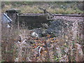
Old Railway Bridge
This crumbling parapet marks the spot where a bridge was constructed to carry the new (c.1890) Fife coast railway over the old Fordell Railway. The Fordell Railway closed in 1946; the bridge has been filled in up to ground level on both sides.
Image: © Robert Struthers
Taken: 31 Oct 2007
0.11 miles
9
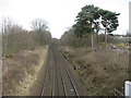
Railway at Donibristle
Part of the Fife Circle. Looking east from a farm track bridge.
Image: © M J Richardson
Taken: 15 Mar 2017
0.17 miles
10

Looking east from Dalgety Bay Halt
Trains cancelled because of a signalling problem.
Image: © M J Richardson
Taken: 4 May 2012
0.20 miles