IMAGES TAKEN NEAR TO
Carnegie Avenue, DUNFERMLINE, KY11 8PJ
Introduction
This page details the photographs taken nearby to Carnegie Avenue, KY11 8PJ by members of the Geograph project.
The Geograph project started in 2005 with the aim of publishing, organising and preserving representative images for every square kilometre of Great Britain, Ireland and the Isle of Man.

There are currently over 7.5m images from over14,400 individuals and you can help contribute to the project by visiting https://www.geograph.org.uk
Image Map
Images are licensed for reuse under creativecommons.org/licenses/by-sa/2.0
Notes
- Clicking on the map will re-center to the selected point.
- The higher the marker number, the further away the image location is from the centre of the postcode.
Image Listing (14 Images Found)
Images are licensed for reuse under creativecommons.org/licenses/by-sa/2.0
Image
Details
Distance
1
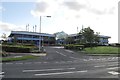
Building Society Building
Headquarters of the Dunfermline Building Society, off Carnegie Drive.
Image: © Robert Struthers
Taken: 7 Oct 2011
0.01 miles
2
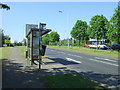
Bus stop and shelter on the A823, St Margaret's Stone
Image: © JThomas
Taken: 25 May 2017
0.07 miles

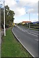
4
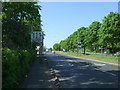
A823 towards Dunfermline
Looking north west.
Image: © JThomas
Taken: 25 May 2017
0.08 miles
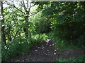
5
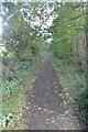
Pitreavie Footpath
This hidden path runs between Carnegie Drive and Pitreavie Sports Ground, and marks the line of the old road as found on old maps of the area.
Image: © Robert Struthers
Taken: 7 Oct 2011
0.09 miles
6
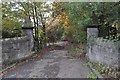
Old Gateway
This entrance is just off the busy A823; it used to lead to St Margaret's Stone, a house or farm named for a nearby ancient rock where Margaret, wife of King Malcolm Canmore, would stop and sit while travelling between Queensferry and Dunfermline.
Image: © Robert Struthers
Taken: 28 Oct 2011
0.09 miles
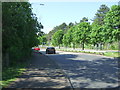
7
Carnegie Drive
Carnegie Drive links Masterton Road to the main A823 road south out of Dunfermline and provides access to several small housing estates.
Image: © Robert Struthers
Taken: 7 Oct 2011
0.09 miles
8
Path into woodland, St Margaret's Stone
Off the A823.
Image: © JThomas
Taken: 25 May 2017
0.10 miles
9
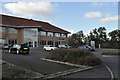
Largo House at Pitreavie Business Park
One of many buildings constructed on the periphery of Dunfermline in the hope of attracting businesses. This one is at least partly occupied by one of the Scottish clearing banks.
Image: © Robert Struthers
Taken: 7 Oct 2011
0.10 miles
10
A823 towards Dunfermline
Looking north west.
Image: © JThomas
Taken: 25 May 2017
0.13 miles