IMAGES TAKEN NEAR TO
Bennachie Way, DUNFERMLINE, KY11 8JA
Introduction
This page details the photographs taken nearby to Bennachie Way, KY11 8JA by members of the Geograph project.
The Geograph project started in 2005 with the aim of publishing, organising and preserving representative images for every square kilometre of Great Britain, Ireland and the Isle of Man.

There are currently over 7.5m images from over14,400 individuals and you can help contribute to the project by visiting https://www.geograph.org.uk
Image Map
Images are licensed for reuse under creativecommons.org/licenses/by-sa/2.0
Notes
- Clicking on the map will re-center to the selected point.
- The higher the marker number, the further away the image location is from the centre of the postcode.
Image Listing (19 Images Found)
Images are licensed for reuse under creativecommons.org/licenses/by-sa/2.0
Image
Details
Distance
1
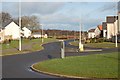
Sandpiper Way
New houses at Duloch to the east of Dunfermline. The view is towards Calais Muir Wood.Image
Image: © Paul McIlroy
Taken: 28 Jan 2007
0.06 miles
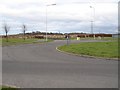
2
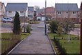
Bennachie Way
An example of the many thousands of new homes that have been built in this area in the last five years.
Image: © Paul McIlroy
Taken: 25 Jan 2007
0.06 miles
3
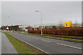
Sandpiper Drive Dunfermline
Viewed looking north towards Amazon Way roundabout.
Image: © edward mcmaihin
Taken: 13 Dec 2013
0.11 miles
4
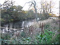
Calais Quarry
Hidden behind a housing estate, the remains of Calais limestone quarry.
Image: © Robert Struthers
Taken: 5 Nov 2007
0.14 miles
5
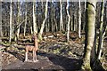
A Rare Species
The elusive Calais Muir Wood Deer, renowned for its ability to remain very still for long periods of time.
Image: © Robert Struthers
Taken: 7 Jan 2018
0.15 miles
6
Calais Muir
The edge of woodland which is slowly being engulfed by an expanding Dunfermline.
Image: © Richard Webb
Taken: 19 Feb 2009
0.16 miles
7
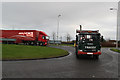
Parcel Force Dunfermline
Some of the huge lorries that operate from the huge retail giant Amazon.
Image: © edward mcmaihin
Taken: 13 Dec 2013
0.16 miles
8
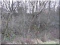
Old Limekiln
Remains of an old limekiln on the east side of Calais Muir wood. This is shown old maps of the area.
Image: © Robert Struthers
Taken: 6 Sep 2007
0.17 miles
9

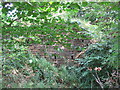
Calais Muir Footpath
The path leads to the south-east corner of the Dunfermline East Expansion development.
Image: © Robert Struthers
Taken: 19 Mar 2016
0.17 miles
10
Undeveloped land by Calais Muir
For some time now there has been a roundabout with just two exits here. It must be awaiting the development of the land between Calais Muir wood and the M90.
Image: © Richard Webb
Taken: 19 Feb 2009
0.18 miles