IMAGES TAKEN NEAR TO
Charles Way, DUNFERMLINE, KY11 3LH
Introduction
This page details the photographs taken nearby to Charles Way, KY11 3LH by members of the Geograph project.
The Geograph project started in 2005 with the aim of publishing, organising and preserving representative images for every square kilometre of Great Britain, Ireland and the Isle of Man.

There are currently over 7.5m images from over14,400 individuals and you can help contribute to the project by visiting https://www.geograph.org.uk
Image Map
Images are licensed for reuse under creativecommons.org/licenses/by-sa/2.0
Notes
- Clicking on the map will re-center to the selected point.
- The higher the marker number, the further away the image location is from the centre of the postcode.
Image Listing (60 Images Found)
Images are licensed for reuse under creativecommons.org/licenses/by-sa/2.0
Image
Details
Distance
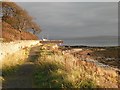
1
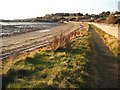
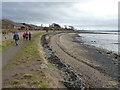
Fife coast path, Limekilns
The path between Rosyth and Limekilns approaching Bruce Haven. The path is also part of the National Cycle Network: route 76.
Image: © Richard Webb
Taken: 15 Oct 2009
0.02 miles
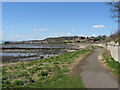
2
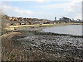
Houses at Bruce Haven
The backs of houses on Charles Way, Limekilns. The path goes round the bay to the remains of Rosyth Church and burial ground. The 'Goliath' crane at the dockyard is visible in the centre distance.
Image: © M J Richardson
Taken: 11 Feb 2013
0.02 miles
3
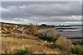
East Limekilns toward Rosyth
New housing on the eastern edge of Limekilns. Beyond can be seen Rosyth dockyard, with the massive 'Goliath' crane used to assemble the Royal Navy's Queen Elizabeth class aircraft carriers. To its right are the three towers of the Queensferry Crossing under construction.
Image: © Robert Struthers
Taken: 31 Oct 2015
0.03 miles
4
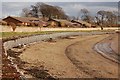
Gabions
These gabions have been installed here to slow down further erosion.
Image: © Paul McIlroy
Taken: 26 Feb 2007
0.05 miles
5
Erosion defences
Stones encapsulated in wire mesh, known as Gabions, are being used to protect the coastline, and the Fife Coastal Path, from erosion here.
Image: © James Allan
Taken: 20 Feb 2012
0.06 miles
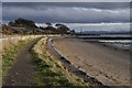
6

Beach, Limekilns
A rocky section of beach between Rosyth and Limekilns.
Image: © Richard Webb
Taken: 15 Oct 2009
0.06 miles
7
Fife Coastal Path
Part of the stretch from Limekilns to Rosyth.
Image: © Robert Struthers
Taken: 31 Oct 2015
0.06 miles
8
Fife Coastal Path
This is a view looking back to Limekilns from near the old Rosyth Church.
Image: © Frank Smith
Taken: 19 Apr 2013
0.07 miles
9
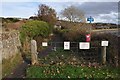
Gateway to Fife Coastal Path
Various warning signs advise you not to walk on the gabions (stone-filled cages to prevent coastal erosion), to pick up your dog's poo, and do not gather shellfish for public consumption.
Image: © Robert Struthers
Taken: 31 Oct 2015
0.07 miles
10
Fife coast path, Limekilns
View along the coastal path towards Rosyth Dockyard.
Image: © Richard Webb
Taken: 15 Oct 2009
0.07 miles