IMAGES TAKEN NEAR TO
Harley Street, DUNFERMLINE, KY11 2NE
Introduction
This page details the photographs taken nearby to Harley Street, KY11 2NE by members of the Geograph project.
The Geograph project started in 2005 with the aim of publishing, organising and preserving representative images for every square kilometre of Great Britain, Ireland and the Isle of Man.

There are currently over 7.5m images from over14,400 individuals and you can help contribute to the project by visiting https://www.geograph.org.uk
Image Map
Images are licensed for reuse under creativecommons.org/licenses/by-sa/2.0
Notes
- Clicking on the map will re-center to the selected point.
- The higher the marker number, the further away the image location is from the centre of the postcode.
Image Listing (15 Images Found)
Images are licensed for reuse under creativecommons.org/licenses/by-sa/2.0
Image
Details
Distance

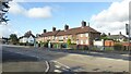
2
Park Road Primary School
On the eastern edge of Rosyth.
Image: © M J Richardson
Taken: 20 Jun 2017
0.09 miles
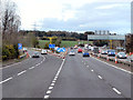
3

Fife : The M90
Heading north through Fife on the M90.
Image: © Lewis Clarke
Taken: 22 Apr 2016
0.10 miles
4
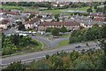
Rosyth from on high
The south-east corner of Rosyth, with the M90 in the foreground.
Image: © Robert Struthers
Taken: 29 Sep 2012
0.11 miles
5
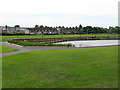
Rosyth Public Park
Recreation ground with pond, putting green, pitches etc.
Image: © M J Richardson
Taken: 20 Jun 2017
0.11 miles
6
![Edinburgh 12 [miles]](https://s3.geograph.org.uk/geophotos/03/06/32/3063223_05976541_120x120.jpg)
Edinburgh 12 [miles]
The end of the M90 heading south at J1, when it becomes the A90 to head over the Forth Road Bridge. One of those frequent occasions when traffic comes to a standstill for no clear reason. Although there are roadworks further ahead in connection with the Second Forth Crossing the traffic flows freely before they finish. The LED sign says' Queue Forth Bridge', but the traffic was flowing freely over the bridge.
Image: © M J Richardson
Taken: 31 Jul 2012
0.13 miles
8
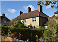
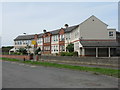
Rosyth: Admiralty Road 'Garden City' housing
Many of the houses at Rosyth are in terraces of four, six or eight, but these ones appear to be 'four-in'a-block'; that is two flats on the ground floor and two on the upper floor, each with their own front door. This block is linked to the one on the right.
The Scottish National Housing Company was set up to provide houses for employees at Rosyth naval dockyard along Garden City lines. Dunfermline Town Council approved the Rosyth town planning scheme in July 1915 and the first houses were occupied in 1916.
Raymond Unwin was expert advisor to the Admiralty in connection with the Rosyth scheme. Alfred Hugh Mottram, as architect for the Scottish National Housing Company, worked on the layout and designed many of the houses.
https://thepastandotherplaces.wordpress.com/2022/10/24/rosyth-garden-town/
Image: © Kay Williams
Taken: 18 Oct 2022
0.19 miles
9
Northbound M90, Junction 2
Traffic leaving for the A823M.
Image: © David Dixon
Taken: 26 Oct 2011
0.21 miles