IMAGES TAKEN NEAR TO
Friary Court, INVERKEITHING, KY11 1NU
Introduction
This page details the photographs taken nearby to Friary Court, KY11 1NU by members of the Geograph project.
The Geograph project started in 2005 with the aim of publishing, organising and preserving representative images for every square kilometre of Great Britain, Ireland and the Isle of Man.

There are currently over 7.5m images from over14,400 individuals and you can help contribute to the project by visiting https://www.geograph.org.uk
Image Map
Images are licensed for reuse under creativecommons.org/licenses/by-sa/2.0
Notes
- Clicking on the map will re-center to the selected point.
- The higher the marker number, the further away the image location is from the centre of the postcode.
Image Listing (223 Images Found)
Images are licensed for reuse under creativecommons.org/licenses/by-sa/2.0
Image
Details
Distance
1
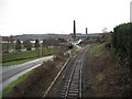
Railway and paper mill, Inverkeithing
A loop of railway running through the port area of Inverkeithing viewed from a footbridge at the bottom of Port Street.
Image: © Richard Webb
Taken: 7 Dec 2008
0.04 miles
2
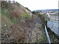
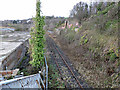
Rosyth Docks railway line
The private line from Inverkeithing to the Royal Dockyard at Rosyth has fallen into disrepair in recent years, with vegetation and fly-tipped rubbish beginning to take a hold. Seen here adjacent to the former Caldwell paper mill site at Inverkeithing.
Image: © Thomas Nugent
Taken: 23 Dec 2015
0.04 miles
3
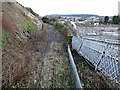
Rosyth Docks railway line
The private line from Inverkeithing to the Royal Dockyard at Rosyth has fallen into disrepair in recent years, with vegetation and fly-tipped rubbish beginning to take a hold. Seen here adjacent to the former Caldwell paper mill site at Inverkeithing.
Image: © Thomas Nugent
Taken: 23 Dec 2015
0.04 miles
4
Rosyth Docks railway line
The private line from Inverkeithing to the Royal Dockyard at Rosyth has fallen into disrepair in recent years, with vegetation and fly-tipped rubbish beginning to take a hold. Seen here adjacent to the former Caldwell paper mill site at Inverkeithing.
Image: © Thomas Nugent
Taken: 23 Dec 2015
0.04 miles
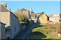
5
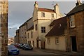
Inverkeithing
This is Bank Street, some of these houses have been here for a long time, the white coloured building is called Thomsoun's House, it was built in 1617.
Image: © Paul McIlroy
Taken: 15 Jan 2007
0.05 miles
6
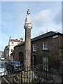
Mercat Cross Inverkeithing
On the corner of Bank St. This cross is believed to date from about 1400, the Unicorn on top was added in 1688.
Image: © Steve Barnes
Taken: 19 Mar 2010
0.05 miles
7

Inverkeithing Mercat Cross
Erected around the year 1400, with a fine finial of a unicorn on top, carved in 1688.
Image: © James Allan
Taken: 26 Mar 2012
0.05 miles
9
Inverkeithing
Inverkeithing used to be thriving seaport,this is reflected in some of the street names still in use today,this picture shows Port Street, or all that's left of it,the church in the picture is St Peter's Church of Scotland.
Image: © Paul McIlroy
Taken: 10 Jan 2007
0.05 miles