IMAGES TAKEN NEAR TO
Roman Road, INVERKEITHING, KY11 1AX
Introduction
This page details the photographs taken nearby to Roman Road, KY11 1AX by members of the Geograph project.
The Geograph project started in 2005 with the aim of publishing, organising and preserving representative images for every square kilometre of Great Britain, Ireland and the Isle of Man.

There are currently over 7.5m images from over14,400 individuals and you can help contribute to the project by visiting https://www.geograph.org.uk
Image Map
Images are licensed for reuse under creativecommons.org/licenses/by-sa/2.0
Notes
- Clicking on the map will re-center to the selected point.
- The higher the marker number, the further away the image location is from the centre of the postcode.
Image Listing (209 Images Found)
Images are licensed for reuse under creativecommons.org/licenses/by-sa/2.0
Image
Details
Distance
1
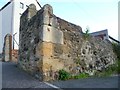
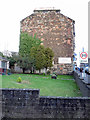
Old town wall, Inverkeithing
The section of stonework on the right looks original from the time when the Royal Burgh had its own enclosing wall. This is a view from the so-called 'Roman Road' taken at the former site of the West Port.
Image: © kim traynor
Taken: 16 Oct 2011
0.02 miles
2
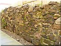
Section of the old town wall, Inverkeithing
This section of wall is hidden away between houses a few yards east of the site of the West Port.
Image: © kim traynor
Taken: 16 Oct 2011
0.02 miles
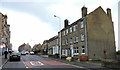
6
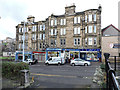
Shops on Hope Street
South of High Street.
Image: © Thomas Nugent
Taken: 23 Dec 2015
0.03 miles
7
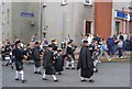
Pipe band, Inverkeithing
At the end of the Inverkeithing Highland Games pipe bands march into the town. Taken in the centre of town, by the Kirk.
Image: © Richard Webb
Taken: 6 Aug 2005
0.03 miles
8
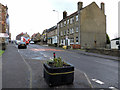
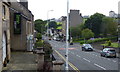
Hope Street Inverkeithing
Looking north.
Image: © Thomas Nugent
Taken: 23 Dec 2015
0.03 miles
9
Hope Street Inverkeithing
Looking north.
Image: © Thomas Nugent
Taken: 23 Dec 2015
0.03 miles
10
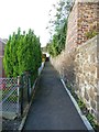
Line of the old town wall, Inverkeithing
This path runs in a straight line between a Victorian tenement block off to the right and more modern housing off to the left. Since it lines up exactly with a surviving section of town wall across the gap created by the roadway where the West Port once stood, I deduce that it follows the line of the old town wall.
Image: © kim traynor
Taken: 16 Oct 2011
0.03 miles