IMAGES TAKEN NEAR TO
Blacklaws Crescent, ANSTRUTHER, KY10 3LJ
Introduction
This page details the photographs taken nearby to Blacklaws Crescent, KY10 3LJ by members of the Geograph project.
The Geograph project started in 2005 with the aim of publishing, organising and preserving representative images for every square kilometre of Great Britain, Ireland and the Isle of Man.

There are currently over 7.5m images from over14,400 individuals and you can help contribute to the project by visiting https://www.geograph.org.uk
Image Map
Images are licensed for reuse under creativecommons.org/licenses/by-sa/2.0
Notes
- Clicking on the map will re-center to the selected point.
- The higher the marker number, the further away the image location is from the centre of the postcode.
Image Listing (174 Images Found)
Images are licensed for reuse under creativecommons.org/licenses/by-sa/2.0
Image
Details
Distance
1
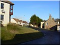
Blacklaws Crescent
The old hamlet of Kilrenny is gradually growing as modern developments such as this take shape around the ancient core of the village.
Image: © James Allan
Taken: 8 Jan 2009
0.02 miles
3
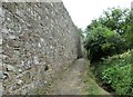
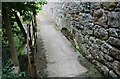
Path in Kilrenny
This path over the Kilrenny Burn connects the Kilrenny play area to Blacklaws Crescent.
See main article https://www.geograph.org.uk/article/Kilrenny
Image: © Bill Kasman
Taken: 2 Aug 2021
0.03 miles
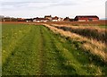
4
Path to picnic area
From Blacklaws Crescent this path leads to the picnic area and children's play area.
See main article https://www.geograph.org.uk/article/Kilrenny
Image: © Bill Kasman
Taken: 24 Jul 2021
0.03 miles
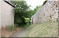
5
Path in Kilrenny
This path crosses the Kilrenny Burn and connects Kilrenny play area to Blacklaws Crescent. The partial archway low down on the right-hand side indicates that this bridge was a later addition which supersedes the wall.
See main article https://www.geograph.org.uk/article/Kilrenny
Image: © Bill Kasman
Taken: 2 Aug 2021
0.03 miles
6
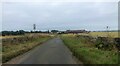
Kilrenny, Fife
This minor road enters the village from the north.
See main article https://www.geograph.org.uk/article/Kilrenny
Image: © Bill Kasman
Taken: 24 Jul 2021
0.04 miles
7
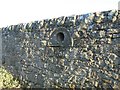
Hemispherical hollow
Unusual feature incorporated into the stone garden wall of Rennyhill House.
Image: © James Allan
Taken: 8 Jan 2009
0.04 miles
8
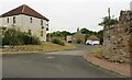
Blacklaws Crescent
Immediately to the right of the two cars a footpath leads to the picnic area and children's play area.
See main article https://www.geograph.org.uk/article/Kilrenny
Image: © Bill Kasman
Taken: 24 Jul 2021
0.04 miles
9
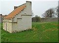
Western Doocot, Kilrenny
The western one of a pair of doocots at Kilrenny. Not seen a pair of doocots this close before. South and east sides.
Image: © Jim Bain
Taken: 15 Apr 2007
0.04 miles
10
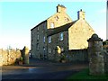
Rennyhill House
An impressive dwelling near the centre of Kilrenny village. Note the unusual decorative 'port-hole' windows high on the gable end.
Image: © James Allan
Taken: 8 Jan 2009
0.04 miles