IMAGES TAKEN NEAR TO
Farm Road, ANSTRUTHER, KY10 3FS
Introduction
This page details the photographs taken nearby to Farm Road, KY10 3FS by members of the Geograph project.
The Geograph project started in 2005 with the aim of publishing, organising and preserving representative images for every square kilometre of Great Britain, Ireland and the Isle of Man.

There are currently over 7.5m images from over14,400 individuals and you can help contribute to the project by visiting https://www.geograph.org.uk
Image Map
Images are licensed for reuse under creativecommons.org/licenses/by-sa/2.0
Notes
- Clicking on the map will re-center to the selected point.
- The higher the marker number, the further away the image location is from the centre of the postcode.
Image Listing (578 Images Found)
Images are licensed for reuse under creativecommons.org/licenses/by-sa/2.0
Image
Details
Distance
1
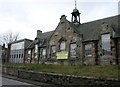
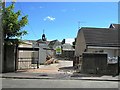
Former Waid Academy Annexe
Before that the Anstruther Easter School, the building has been acquired for conversion into three houses.
Image: © Richard Sutcliffe
Taken: 17 Mar 2019
0.01 miles
2
Former Waid Academy Annexe
Before that the Anstruther Easter School, the building has been acquired for conversion into three houses.
Image: © Richard Sutcliffe
Taken: 17 Mar 2019
0.01 miles
3
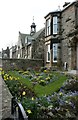
Spring flowers, garden on Crail Road
Daffodils and Scillas make a colourful display. In the background is the former Waid Academy Annexe (before that the Anstruther Easter School).
Image: © Richard Sutcliffe
Taken: 17 Mar 2019
0.01 miles
4
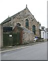
Former Anstruther Evangelical Church
Built as the Anstruther Congregational Church [http://www.scottishchurches.org.uk/sites/site/id/7761/name/Anstruther+Evangelical+Church+Anstruther+Easter+Fife] in 1833.
Image: © Richard Sutcliffe
Taken: 17 Mar 2019
0.02 miles
5

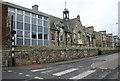
Former Anstruther Primary School
This old school building looks like it is being converted into flats. The primary school has moved to a modern building just North of here.
Image: © Mark Anderson
Taken: 1 Sep 2020
0.02 miles
6
Demolition site, Anstruther
In Farm Road, this annexe to the old Waid Academy, Anstruther is being demolished as part of the upgrading of the school https://www.thecourier.co.uk/news/local/fife/240053/backing-for-new-24-million-waid-academy/
Image: © Bill Kasman
Taken: 5 Aug 2017
0.02 miles
7
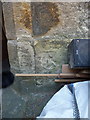
OS benchmark - Cellardyke, former Independent Chapel on Crail Road
A very weathered OS cutmark on the doorway of the old church/chapel near the roundabout in Cellardyke; originally levelled at 12.844m above Ordnance Datum Newlyn.
Image: © Richard Law
Taken: 10 May 2016
0.02 miles
8
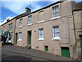
6 - 8 Rodger Street, Anstruther Easter
Early 19th century in origin, and Category C listed https://britishlistedbuildings.co.uk/200380839-6-8-rodger-street-anstruther-easter-kilrenny#.YoAPnejMLIU in 1972
Image: © Richard Law
Taken: 6 May 2022
0.04 miles
10
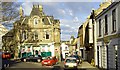
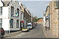
Anstruther High Street
The east end of the High Street.
Image: © Jim Bain
Taken: 10 Apr 2007
0.04 miles