1
Cellardyke Harbour, Fife
Panoramic view of Cellardyke Harbour, in the East Neuk of Fife.
Image: © Jerzy Morkis
Taken: 29 Aug 2020
0.01 miles
2
Cellardyke Harbour
Tablecloths blow in the breeze to dry on the communal washing lines on the harbour wall.
Image: © Anne Burgess
Taken: 3 Jul 2018
0.01 miles
3
22 and 24 Shore Street, Cellardyke
Category C listed properties.
Image: © Richard Sutcliffe
Taken: 17 Mar 2019
0.02 miles
4
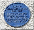
Blue plaque in memory of Captain Alexander Rodger
On the wall of 26 Shore Street, Cellardyke [https://www.geograph.org.uk/photo/6092840].
The plaque reads:
CAPTAIN
ALEXANDER RODGER
1802-1877
WAS BORN IN THIS HOUSE
FISHERMAN WHO BECAME
MASTER OF THE CHINA TEA
CLIPPER 'KATE CARNIE'
AND OWNER OF THE CLIPPER
SHIPS 'LAHLOO','MIN' AND
'TAEPING' AMONG OTHERS.
Image: © Richard Sutcliffe
Taken: 17 Mar 2019
0.02 miles
5
Shore Street, Cellardyke, Fife
Traditional houses on the north side of Shore Street, Cellardyke, in the East Neuk of Fife.
Image: © Jerzy Morkis
Taken: 29 Aug 2020
0.02 miles
6
21st Century, but Monday is still washday in Cellardyke
Although Peter Aikman has reminded me that 60 years ago every weekday was a washday, as each house had a different day on which they used the poles and lines for drying. Houses at the old harbour.
Image: © M J Richardson
Taken: 22 Jun 2009
0.02 miles
7
Fishing Village Houses
Typical of the Neuk of Fife these attractive houses in the Royal Burgh of Cellardyke have pantiled roofs
Image: © Glen Breaden
Taken: 19 Mar 2009
0.02 miles
8
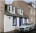
26 Shore Street, Cellardyke
Category C listed building with a blue plaque.
Image: © Richard Sutcliffe
Taken: 17 Mar 2019
0.02 miles
9
Harbour wall, Cellardyke
Part of the harbour (Skinfast Haven) which dates from about 1452, constructed with the assistance of Dutch dyke builders. This section shows the characteristic vertically set blockwork from that period - here resting directly onto the sandstone bedrock.
The harbour is Category B listed [http://portal.historicenvironment.scot/designation/LB36034].
Image: © Richard Sutcliffe
Taken: 17 Mar 2019
0.02 miles
10
Harbour, Cellardyke
A view across the harbour at Cellardyke in Fife.
Image: © William Starkey
Taken: 15 Jul 2014
0.02 miles


