IMAGES TAKEN NEAR TO
Toft Court, ANSTRUTHER, KY10 2QR
Introduction
This page details the photographs taken nearby to Toft Court, KY10 2QR by members of the Geograph project.
The Geograph project started in 2005 with the aim of publishing, organising and preserving representative images for every square kilometre of Great Britain, Ireland and the Isle of Man.

There are currently over 7.5m images from over14,400 individuals and you can help contribute to the project by visiting https://www.geograph.org.uk
Image Map
Images are licensed for reuse under creativecommons.org/licenses/by-sa/2.0
Notes
- Clicking on the map will re-center to the selected point.
- The higher the marker number, the further away the image location is from the centre of the postcode.
Image Listing (207 Images Found)
Images are licensed for reuse under creativecommons.org/licenses/by-sa/2.0
Image
Details
Distance
1
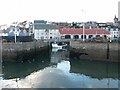
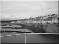
Pittenweem fish sheds and boat
The new harbour taken from the outer wall. The big red roofed building is the fish sheds where the catch is sold and a fleet of little vans fan out to take the fish out to the shops each morning.
Image: © Jim Bain
Taken: 16 Sep 2005
0.05 miles
2
Rails and rain
Looking west along the Forth towards Edinburgh with rainstorms over the area of the bridges.
Image: © Jim Bain
Taken: 16 Sep 2005
0.05 miles
3
Waggon Road, Pittenweem
Old road from Coal Farm to Pittenweem harbour built for the transportation of coal from the pits around Coal and Waterless Farm area.
Image: © Jim Bain
Taken: 20 Jul 2007
0.07 miles
4
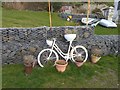
White bicycle as planter
On the western outskirts of Pittenweem.
Image: © Oliver Dixon
Taken: 2 Apr 2019
0.08 miles
5
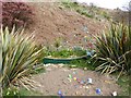
Model boat as planter
On the western outskirts of Pittenweem.
Image: © Oliver Dixon
Taken: 2 Apr 2019
0.08 miles
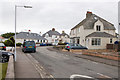
6
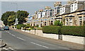
Viewforth Place, Pittenweem
By the north of the A917.
Image: © Jim Bain
Taken: 21 Sep 2008
0.09 miles
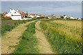
7
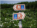
Footpath signs, Fife Coastal Path
Signs at Pittenweem for the 183km path that links the Firths of Forth and Tay.
Image: © Jim Barton
Taken: 9 Aug 2022
0.09 miles
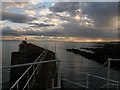
8
West Shore, Pittenweem
The white painted fishermen's cottages from the breakwater at the entrance to Pittenweem Harbour
Image: © Joan Murfitt
Taken: 12 Jul 2011
0.09 miles
9
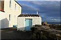
Outhouse
Old outhouse at Pittenweem, times have changed when people would have to go outside to use a toilet. They were given many names locally such as privy, cludgie, lavvy or in politer company the water closet. These outhouses are mainly used now for storage.
Image: © Mary Rodgers
Taken: 29 Sep 2020
0.09 miles