IMAGES TAKEN NEAR TO
St. Monans, ANSTRUTHER, KY10 2DD
Introduction
This page details the photographs taken nearby to KY10 2DD by members of the Geograph project.
The Geograph project started in 2005 with the aim of publishing, organising and preserving representative images for every square kilometre of Great Britain, Ireland and the Isle of Man.

There are currently over 7.5m images from over14,400 individuals and you can help contribute to the project by visiting https://www.geograph.org.uk
Image Map
Images are licensed for reuse under creativecommons.org/licenses/by-sa/2.0
Notes
- Clicking on the map will re-center to the selected point.
- The higher the marker number, the further away the image location is from the centre of the postcode.
Image Listing (20 Images Found)
Images are licensed for reuse under creativecommons.org/licenses/by-sa/2.0
Image
Details
Distance
1
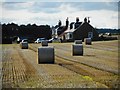
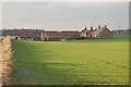
Straw bales beside Craigiewells
Seen from the road to Abercrombie.
Image: © Richard Sutcliffe
Taken: 23 Sep 2019
0.01 miles
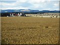
3
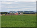
Craigiewells Farm
Craigiewells viewed from the east, with Largo Law in the distance.
Image: © Scott Cormie
Taken: 7 Jul 2019
0.02 miles
4
Craigiewells farm across a field of wheat
Image: © Richard Law
Taken: 25 Jun 2012
0.02 miles
5

Autumn at Craigiewells, near Abercrombie
Image: © Becky Williamson
Taken: 3 Nov 2019
0.03 miles
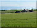
6
Craigiewells
Craigiewells from the Abercrombie road.
Image: © Jim Bain
Taken: 16 Dec 2007
0.04 miles
7
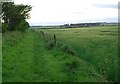
Towards Craigiewells
The western end of the Sandy Kirn path with Craigwells on the right of shot.
Image: © Jim Bain
Taken: 12 May 2007
0.05 miles
8
Craigiewells
Seen from the road to Abercrombie.
Image: © Richard Sutcliffe
Taken: 23 Sep 2019
0.06 miles
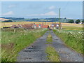
9
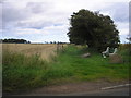
The Public Footpath to Sandy Kirn
The view of what would appear to be the start of the footpath to Sandy Kirn at the point where it leaves the St Monans to Abercrombie road.
Image: © Sandy Gemmill
Taken: 16 Aug 2007
0.11 miles
10
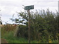
Footpath to Sandy Kirn
The sign at the start of the footpath to Sandy Kirn Image There is no trace of such a name on any map and Jim Bain indicates in Image that he has spent 8 years looking for it. Google just gives Image when linked to St Monans.
Image: © Sandy Gemmill
Taken: 16 Aug 2007
0.11 miles