IMAGES TAKEN NEAR TO
DUNBEATH, KW6 6EG
Introduction
This page details the photographs taken nearby to KW6 6EG by members of the Geograph project.
The Geograph project started in 2005 with the aim of publishing, organising and preserving representative images for every square kilometre of Great Britain, Ireland and the Isle of Man.

There are currently over 7.5m images from over14,400 individuals and you can help contribute to the project by visiting https://www.geograph.org.uk
Image Map
Images are licensed for reuse under creativecommons.org/licenses/by-sa/2.0
Notes
- Clicking on the map will re-center to the selected point.
- The higher the marker number, the further away the image location is from the centre of the postcode.
Image Listing (43 Images Found)
Images are licensed for reuse under creativecommons.org/licenses/by-sa/2.0
Image
Details
Distance
1
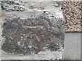
Benchmark at Dunbeath Village
An old cut mark on a private house.
Image: © David Bremner
Taken: 14 Aug 2022
0.05 miles
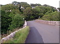
3
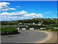
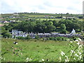
Hairpin Bend
Hairpin bend on the old A9 at Dunbeath and showing the oldest part of the village beyond the Strath
Image: © John MacKenzie
Taken: 3 Jun 2011
0.06 miles
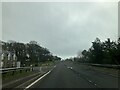
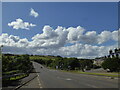
6
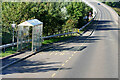
Bus Stop near Dunbeath Bridge
A9 southbound.
Image: © David Dixon
Taken: 26 Sep 2021
0.06 miles
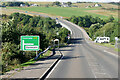
7
Upper Portomin Road
View, from road to Balcladich, over the Dunbeath Water bridges.
Image: © Stanley Howe
Taken: 26 Jun 2007
0.06 miles