IMAGES TAKEN NEAR TO
Portormin Road, DUNBEATH, KW6 6EF
Introduction
This page details the photographs taken nearby to Portormin Road, KW6 6EF by members of the Geograph project.
The Geograph project started in 2005 with the aim of publishing, organising and preserving representative images for every square kilometre of Great Britain, Ireland and the Isle of Man.

There are currently over 7.5m images from over14,400 individuals and you can help contribute to the project by visiting https://www.geograph.org.uk
Image Map
Images are licensed for reuse under creativecommons.org/licenses/by-sa/2.0
Notes
- Clicking on the map will re-center to the selected point.
- The higher the marker number, the further away the image location is from the centre of the postcode.
Image Listing (66 Images Found)
Images are licensed for reuse under creativecommons.org/licenses/by-sa/2.0
Image
Details
Distance
1
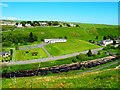
Dunbeath Playing Field
Picture shows the field and Village Hall beside Dunbeath Water
Image: © John MacKenzie
Taken: 3 Jun 2011
0.04 miles
2
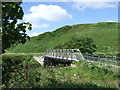
Footbridge over Dunbeath Water
Seen from Portomin Road.
Image: © Stanley Howe
Taken: 26 Jun 2007
0.05 miles
3
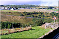
View of Dunbeath
Dunbeath from across the Bay
Image: © John MacKenzie
Taken: 18 Mar 2012
0.07 miles
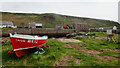
4
Dunbeath
A view across the steep valley at the mouth of Dunbeath Water.
Image: © David Dixon
Taken: 28 Sep 2021
0.10 miles
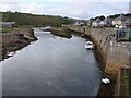
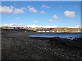
10
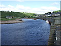
Water of Dunbeath
About to enter the North Sea at Dunbeath Bay. The Portomin quays are on the right; the new bridge carrying the A99 is in the distance.
Image: © Stanley Howe
Taken: 26 Jun 2007
0.13 miles