IMAGES TAKEN NEAR TO
Burray, ORKNEY, KW17 2SY
Introduction
This page details the photographs taken nearby to KW17 2SY by members of the Geograph project.
The Geograph project started in 2005 with the aim of publishing, organising and preserving representative images for every square kilometre of Great Britain, Ireland and the Isle of Man.

There are currently over 7.5m images from over14,400 individuals and you can help contribute to the project by visiting https://www.geograph.org.uk
Image Map
Images are licensed for reuse under creativecommons.org/licenses/by-sa/2.0
Notes
- Clicking on the map will re-center to the selected point.
- The higher the marker number, the further away the image location is from the centre of the postcode.
Image Listing (5 Images Found)
Images are licensed for reuse under creativecommons.org/licenses/by-sa/2.0
Image
Details
Distance
1
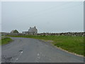
Dry-stane dykes
Near Northtown on Burray.
Image: © James Allan
Taken: 13 May 2017
0.03 miles
2
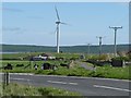
Farmland at Northtown, Burray, Orkney Islands
Showing the junction of a minor road with the A961.
The wind turbine is at Northfield http://www.geograph.org.uk/photo/2631610 .
Image: © Robin Drayton
Taken: 12 May 2011
0.03 miles
3
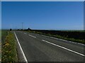
Northtown Hill
The main road crosses the top of Northtown Hill which is a TumP.
Image: © David Bremner
Taken: 19 May 2022
0.15 miles
4
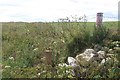
North Links, Burray
Fence beside a large area of rough grassland on the northeast corner of Burray.
Image: © Richard Webb
Taken: 8 Aug 2015
0.16 miles
5
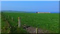
Pasture at Gillietrang
The waters of Echnaloch Bay in the distance.
Image: © Gordon Brown
Taken: 31 May 2018
0.21 miles