IMAGES TAKEN NEAR TO
Papa Westray, ORKNEY, KW17 2BU
Introduction
This page details the photographs taken nearby to KW17 2BU by members of the Geograph project.
The Geograph project started in 2005 with the aim of publishing, organising and preserving representative images for every square kilometre of Great Britain, Ireland and the Isle of Man.

There are currently over 7.5m images from over14,400 individuals and you can help contribute to the project by visiting https://www.geograph.org.uk
Image Map (Loading...)


Getting Data...Please wait
Leaflet Map data © OpenStreetMap
Images are licensed for reuse under creativecommons.org/licenses/by-sa/2.0
Notes
- Clicking on the map will re-center to the selected point.
- The higher the marker number, the further away the image location is from the centre of the postcode.
Image Listing (25 Images Found)
Images are licensed for reuse under creativecommons.org/licenses/by-sa/2.0
Image
Details
Distance
2
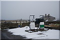
Petrol pumps, Papa Westray
Didn't like to ask how much per litre
Image: © hayley green
Taken: 22 Feb 2010
0.04 miles
3
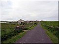
Road leading from old pier back to Holland
Papa Westray
Image: © Dumgoyach
Taken: 24 Jun 2005
0.04 miles
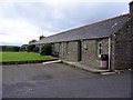
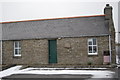
6
Papay Parish Kirk
At the centre of Papay (Papa Westray), the kirk is next to the school.
Image: © Lis Burke
Taken: 24 May 2006
0.06 miles
7
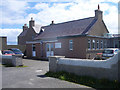
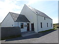
Papa Westray Community School
The heart of the island.
Image: © Lis Burke
Taken: 24 May 2006
0.06 miles
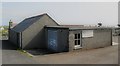
8
Papay Community Shop
The only shop on the island (bar the craft shop), this is run as a community co-op and is very proudly fair trade certified
Image: © hayley green
Taken: 22 Feb 2010
0.09 miles
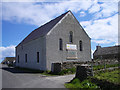
9
Papa Westray: the church
A simple church in the main village part of the island.
Image: © Chris Downer
Taken: 28 Jul 2011
0.09 miles
10
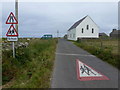
Papa Westray: approaching the church
The little church stands alongside the road running across the island to the eastern side. The road markings and signage are akin to a far more suburban location than the quiet traffic-less scene we are in. (The school is just beyond the church.)
Image: © Chris Downer
Taken: 28 Jul 2011
0.09 miles